
On Saturday afternoon, Vaudreuil-Dorion joined the list of municipalities that are officially in a state of emergency due to encroaching flood waters.
Montreal, Ottawa and many smaller communities across the expansive flood zone have declared states of emergency, prompting the federal government to deploy hundreds of soldiers to help with sandbagging and other relief operations.
Vaudreuil-Dorion officials declared a state of emergency at approximately 11:30 a.m.
The Galipeault Bridge - a major western link to the Island of Montreal - is closed indefinitely due to safety concerns prompted by rising water levels.
Transport Quebec announced the complete closure of the bridge between Ile-Perrot and Sainte-Anne-de-Bellevue early Saturday morning.
This leaves the nearly eleven thousand residents of Île-Perrot and other nearby communities with a significant detour via highways 20 and 30, to get up to the Eastbound 40 and then across the l'Île-aux-Tourtes bridge.
Detour information is available via the map below:
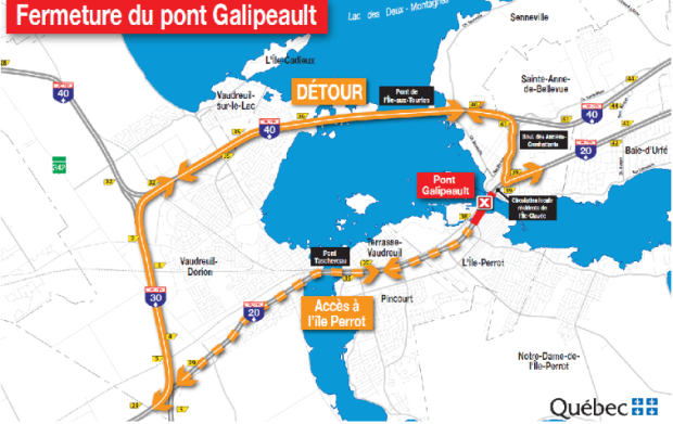
(Map courtesy of Transport Quebec.)
The l'Ile-aux-Tourtes bridge, however, is also on watch due to rising floodwater.
The Transport Ministry has also dispatched frontline workers to install dikes on Highway 40 right after the Ile Aux Tourtes Bridge in Vaudreuil.
Witnesses say water is reportedly rising close to the side of the highway.
Transport Quebec also announced that the toll on Highway 30 has been removed temporarily - until the bridge reopens to traffic - to facilitate travel.
Environment Canada's rainfall warning was lifted for the Island of Montreal, Chateauguay - La Prairie, Laval, and Longueuil - Varennes - but Public Security officials still expect flood levels to rise.
The latest assessment, released by Urgence Quebec Friday night, shows a steady increase in the number of victims across the province: 3017 homes are currently flooded, 2736 are inaccessible due to water accumulation, and 1796 citizens were forced to evacuate.
More rain forecast for flood-weary communities in Quebec and beyond
It's shaping up to be another anxious weekend for flood-weary communities in Ontario, Quebec and New Brunswick.
More rain is in the forecast for an area stretching from cottage country north of Toronto, all the way east through Quebec and Atlantic Canada.
Officials estimate the Ottawa River will rise nearly a metre over the next few days, well above its peak in a 2017 flood that was thought to have been a once-a-century event.
A close eye is also being kept on a hydroelectric dam, on a tributary of the Ottawa River between Ottawa and Montreal, that's at risk of failing.
Water at the Chute-Bell dam has reached levels expected once every 1,000 years, but Hydro-Quebec says it's confident the structure is solid.
Environment Canada forecast significant rainfall - 30 to 60 millimetres in addition to run-off from melting snow - but lifted the rainfall warning just before noon on Saturday.
In a statement, municipal authorities recognized that the water accumulation will likely weaken temporary walls and dikes.
(With files from CJAD 800, The Canadian Press)


