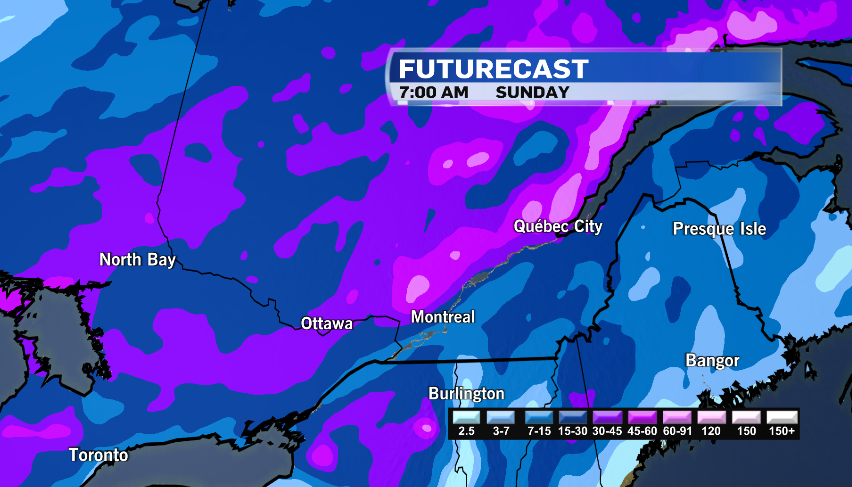
Get ready for a snowy weekend as another storm travels to Montreal
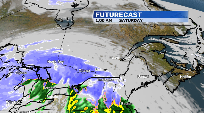
Get ready to do more shovelling -- another Texas low is moving into Quebec and should bring an additional round of steady snow beginning Friday night.
Environment and Climate Change Canada has issued snowfall warnings for the Montreal area, with at least 15 centimetres of snow expected.
Winter storm warnings are also in place west and north of the city.
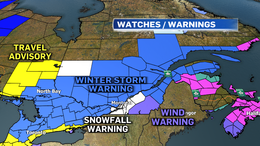
The Ottawa Valley may get 15 to 25 cm of snow, while the Laurentians could see as much as 40 cm. The Quebec City region is expecting 20 to 30 cm.
Wind gusts up to 70 km/h are expected to significantly reduce visibility at times.
The Eastern Townships will see less than 10 cm of snow with this system but winds will be a factor. Gusts of up to 90 km/h could cause tree branches to come down and lead to possible power outages.
Snow is expected in Montreal around midnight and will continue through to Saturday morning.
The city is expecting wind gusts up to 50 km/h, causing blowing and drifting snow on the roads, which could make for difficult travel conditions.
Snow could become mixed with patchy freezing rain and rain around midday.
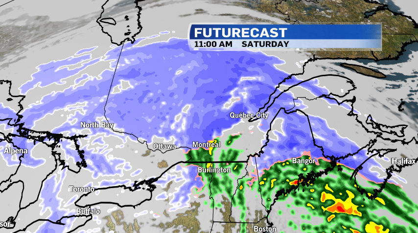
Blowing and drifting snow should continue through Sunday.


CTVNews.ca Top Stories

Inside Canada's chaotic response to avian flu
A CFIA official is calling it the 'largest animal health emergency that this country has ever had to face.' A joint IJF/CTV News investigation looks into Canada's response to the bird flu pandemic, and how it's ravaged the country's farms.
What Donald Trump's election victory could mean for Canada
Following president-elect Donald Trump's decisive election victory, there are sure to be significant knock-on effects for Canada. Here's a look at the different areas in which a second Trump presidency may affect Canadians.
Cuba left reeling after Category 3 hurricane ravages island and knocks out power grid
Cuba was left reeling Thursday after a fierce Category 3 hurricane ripped across the island and knocked out the country's power grid.
The world's 10 richest people got a record US$64 billion richer from Trump's re-election
Wednesday wasn't just a good day for Donald Trump. The wealth of the world’s 10 richest people also soared by a record amount, according to Bloomberg’s Billionaire Index.
Influencer is banned from future NYC marathons for bringing a camera crew to last weekend's race
A social media influencer from Texas was disqualified from last weekend's New York City Marathon and banned from future competitions after he ran the race with a camera crew on e-bikes in tow.
Sleepy during the day? You may be at higher risk for a pre-dementia syndrome, study finds
If you find yourself sleepy during your daily activities in your older age, you may need to consider it more than an inconvenience — since the fatigue may indicate you’re at higher risk for developing a condition that can lead to dementia, a new study has found.
B.C. man discovers 115 stuffed animals hidden behind wall, begins donating them to people around world
As Connor Nijsse prepared to remove some old drywall during his garage renovation, he feared the worst.
Kamala Harris concedes: Here's what she said in her speech
Democratic Vice-President Kamala Harris conceded the U.S. election to Republican Donald Trump Wednesday afternoon, telling her supporters that her 'heart is full.'
Newfoundland hockey player suspended, banned from local arena after off-ice fight with fan
A combination of a thrown stick and thrown punches have given a senior hockey player in Newfoundland a three-game suspension and an indefinite ban from one of his league's six arenas.
Shopping Trends
The Shopping Trends team is independent of the journalists at CTV News. We may earn a commission when you use our links to shop. Read about us.


Toronto
-

'We weren't using it': Toronto-area man shocked after glass washing machine door spontaneously shatters
A Toronto-area man is shocked after the glass door of his washing machine spontaneously shattered.
-
1,200 Brampton city workers go on strike
Some 1,200 City of Brampton workers are on strike as of this morning, affecting a range of possible services from recreation to transit.
-
Man dies after stabbing in Scarborough
A man is dead following an early-morning stabbing in Scarborough’s West Hill area.
Ottawa
-

'Positive movement' in Ottawa's real estate market in October with home sales up nearly 50%
Ottawa home sales increased nearly 50 per cent in October, as "consumer confidence is getting stronger' following a fourth cut in interest rates this year.
-
Flair Airlines departs Ottawa Airport
Flair Airlines has departed the Ottawa International Airport, citing "insufficient demand to compensate for the airport's high fees."
-
A look at the new Ottawa Charge jerseys
The Professional Women's Hockey League unveiled the new jerseys for the Ottawa Charge on Thursday, ahead of the start of the second season for the league.
Atlantic
-

Sacred ground: Canadian delegation in Belgium for Remembrance Day ceremonies
CTV News is part of a Canadian delegation commemorating fallen Indigenous Canadian service members from the First World War. The group will attend a series of ceremonies and events throughout Belgium right up until Remembrance Day.
-
'More common than we want to believe': Two recent N.S. homicides linked by intimate partner violence
The RCMP has confirmed the deaths of two seniors in Cole Harbour, N.S., were the result of intimate partner violence -- less than three weeks after another instance of intimate partner violence resulted in two deaths in Enfield, N.S.
-
Newfoundland hockey player suspended, banned from local arena after off-ice fight with fan
A combination of a thrown stick and thrown punches have given a senior hockey player in Newfoundland a three-game suspension and an indefinite ban from one of his league's six arenas.
N.L.
-

Newfoundland beach blobs are plastic pollution, but source remains unknown: scientist
A Memorial University scientist says the mysterious white blobs washing up on Newfoundland beaches are actually gobs of plastic -- and they need to be cleaned up.
-
Teachers in Newfoundland and Labrador say violence is on the rise, averaging 22 incidents per school day
School staff are being struck more often, students are fighting more frequently, and police are increasingly being called to school grounds, according to data compiled and released this week by the Newfoundland and Labrador Teachers' Association.
-
Newfoundland and Labrador cautioned about growing debt as province touts success
Newfoundland and Labrador's auditor general has issued a warning about the province's financial position as the government announced it would finish the 2024-25 fiscal year with a higher-than-expected deficit.
Northern Ontario
-

One sent to hospital in two-vehicle crash on Lasalle extension in Greater Sudbury
Traffic on the Lasalle extension in Sudbury came to a halt Wednesday afternoon after the roof of a silver BMW was sheared off in a crash.
-
Details released of dramatic police shootout with murder suspect near Timmins, Ont.
Ontario's Special Investigation Unit has cleared police actions in a shootout with a murder suspect last June that left one police officer with bullet wounds to his neck.
-
Various popular brands of bread and buns have been recalled in Canada
Dozens of popular brands of bread have been recalled in Canada after pieces of metal were discovered in some of the products.
London
-

Derelict building might get date with wrecking ball — finally
A longtime eyesore in east London has decayed to the point of requiring more drastic action by city hall.
-
London’s only 24/7 drop-in space in jeopardy under new encampment funding rules
There is more clarity on a city council resolution that appeared to forbid resting spaces on main streets of business improvement areas.
-
Battling the memories: Local war veteran speaks about his time in the Second World War
Like many veterans of the Second World War, Allan Brunsden came to terms with his battle memories late in life. At 99, he keeps his therapy dog ‘Bo’ close by in case his recollections get the better of him.
Kitchener
-

Cambridge council supports Ontario's Big City Mayors resolution addressing homelessness
A plea from Ontario Big City Mayors (OBCM) to the province to address homelessness now has the backing of most of Cambridge City Council.
-
Donald Trump wins U.S. presidential election, Harris concedes in speech about democracy
Donald Trump was elected the 47th president of the United States on Wednesday, an extraordinary comeback for a former president who refused to accept defeat four years ago, sparked a violent insurrection at the U.S. Capitol, was convicted of felony charges and survived two assassination attempts.
-
Various popular brands of bread and buns have been recalled in Canada
Dozens of popular brands of bread have been recalled in Canada after pieces of metal were discovered in some of the products.
Windsor
-

Shots fired in downtown Windsor parking lot
Windsor police are looking for a suspect after shots were fired in a downtown parking lot.
-
County council gets 2025 budget preview
The initial budget increase was projected at 11.16 per cent, representing another $17.3-million dollars in taxes for the county. Administration has trimmed that to a 6.36 per cent increase, accounting for nearly $11.5 million in new tax revenue.
-
Rollover crash into house in Amherstburg
A driver had to be extracted from a vehicle after a rollover crash into a house in Amherstburg.
Barrie
-

One person found dead after house fire in Wasaga Beach
One person has died after fire broke out in a house in Wasaga Beach.
-
Local researchers initiate study during Domestic Violence Awareness month
Waypoint Research Institute wants to hear from women and others affected by domestic violence.
-
Human trafficking trial resumes with woman alleging abuse, exploitation
The trial for a Simcoe County couple accused of human trafficking resumed in a Bradford courtroom on Wednesday, with the complainant testifying the defendants left her physically, emotionally, and mentally exhausted.
Vancouver
-

What does a Trump presidency mean for Canada and B.C.?
Hours after Donald Trump's win, the impact his presidency will have in Canada was front and centre in Ottawa during Question Period, where Opposition Leader Pierre Poilievre and Prime Minister Trudeau traded shots Wednesday.
-
VPD data sheds more light on hate crimes in Vancouver
Data released through a Freedom of Information request is providing greater insight into hate crimes in Vancouver.
-
Convicted fraudster banned from financial markets in B.C.
B.C.'s financial markets regulator has permanently banned a convicted fraudster from various investment activities.
Vancouver Island
-
What does a Trump presidency mean for Canada and B.C.?
Hours after Donald Trump's win, the impact his presidency will have in Canada was front and centre in Ottawa during Question Period, where Opposition Leader Pierre Poilievre and Prime Minister Trudeau traded shots Wednesday.
-
B.C. man discovers 115 stuffed animals hidden behind wall, begins donating them to people around world
As Connor Nijsse prepared to remove some old drywall during his garage renovation, he feared the worst.
-
B.C. court allows police to apply to dispose of evidence from Robert Pickton's farm
The B.C. Supreme Court says it has jurisdiction to order the disposal of thousands of pieces of evidence seized from Robert Pickton's pig farm decades ago, whether it was used in his murder trial or not.
Winnipeg
-

Icy roads a factor in 19-vehicle crash
Police are investigating after 19 vehicles were involved in a fatal collision on a Manitoba roadway.
-
Crash on Chief Peguis Trail leaves pedestrian dead
A Wednesday night crash on Chief Peguis Trail has left one person dead.
-
Manitoba premier strikes optimistic tone on relations with new Trump administration
Manitoba Premier Wab Kinew says he will continue to push the benefits of trade with the United States now that the election south of the border is over.
Calgary
-

Crews respond to fire at Deer Ridge home
Firefighters were called to the southeast community of Deer Ridge after a blaze broke out near a home early Thursday.
-
Accused serial rapist's trial delayed again frustrating his alleged victims
The trial of Richard Mantha, 60, who faces nearly two dozen charges of drugging and raping several women from Calgary's sex trade, has been delayed again.
-
Gunfire erupts in northwest Calgary; police say shooting was targeted
Police are investigating after a shooting in Calgary's northwest on Wednesday night. It happened in the 200 block of Nolan Hill Drive N.W. around 9:30 p.m.
Edmonton
-

Golden Knights end road woes to spoil McDavid's return for Oilers
Their first road win of the season was a memorable one for the Vegas Golden Knights.
-
Inside Canada's chaotic response to avian flu
A CFIA official is calling it the 'largest animal health emergency that this country has ever had to face.' A joint IJF/CTV News investigation looks into Canada's response to the bird flu pandemic, and how it's ravaged the country's farms.
-
Alberta asks municipalities to name oil companies not paying taxes, reeve says no use
The Alberta government is asking rural municipalities to send letters naming oil and gas companies that aren't paying their property taxes, but one rural leader says there's no hope for enforcement.
Regina
-

Here's a look at the important issues in Regina, according to voters
A recent poll conducted by CTV News in partnership with Insightrix Research is giving a look at what issues matter most for prospective voters in Saskatchewan's capital city ahead of the Nov. 13 municipal election.
-
'Dangerously high' levels of Radon gas present in one in three Sask. homes: study
One in three homes in Saskatchewan appear to have dangerously high radon gas levels, according to a recent report from the Evict Radon National study team.
-
Meet Regina mayoral candidate: Sandra Masters
Regina's incumbent mayor faces a crowded field of 10 challengers in her quest for re-election. She insists that she has the necessary experience and the right plan to keep Regina moving forward.
Saskatoon
-

Homelessness, shelters and crime top of mind for Saskatoon voters, new poll shows
Social issues are top of mind for Saskatoon residents as they prepare to head to the polls on Wednesday to choose their next mayor and councillors.
-
What is typhoid fever and how did it end up in Martensville, Saskatchewan?
The Saskatchewan Health Authority (SHA) is warning about a possible exposure of salmonella typhi — a bacteria that can cause typhoid fever.
-
Meet Saskatoon mayoral candidate Gordon Wyant
After serving as a 14-year MLA and a 12-year cabinet minister, handling key portfolios like justice, education and serving as deputy premier, Wyant is back in Saskatoon running for mayor.