'Major' winter storm headed for southern Quebec just before holiday weekend
A "major" winter storm system is headed for southern Quebec at the end of the week, prompting warnings to drivers ahead of one of the busiest travel weekends of the year.
- GET THE LATEST HERE: Major storm moving into Quebec Thursday night
Climatologists have dubbed the storm headed to Ontario and Quebec just before the holiday weekend as a "weather bomb" due to a rapid drop in pressure in the weather system.
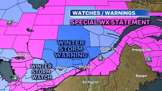
Environment Canada has issued weather watches and warnings that stretch from Ontario to Atlantic Canada. A special weather statement is in effect for southern Quebec, including Montreal, Laval, Longueuil, and the Châteauguay-La Prairie area.
- EXPLAINED: What is a weather bomb
The weather agency describes the storm as a mixed bag of weather that is expected to bring heavy snow, rain, and freezing rain, as well as a "quite drastic temperature drop."
Here's how the storm will affect the region.
THURSDAY
Beginning Thursday night, the storm will start with "particularly heavy" snow as temperatures hover around the freezing mark, according to Environment Canada.
"This weight, added to the snow already on the ground, combined with the strong winds expected, may damage some structures or tree limbs. Local power outages are possible," Environment Canada said.
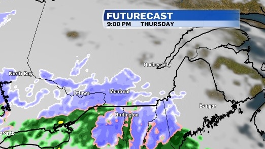
Areas north of the St. Lawrence River can expect to see between 15 and 30 centimetres of snow Thursday night through Friday. Montreal could see about 10 centimetres of snow, which could cause tree branches to come down and possible power outages.
Hydro-Quebec said its crews will be monitoring the storm. In a tweet, it shared a link with tips to prepare people in case of a power outage.
The high for Thursday will be -2 C, with a low of -3 C for the evening.
FRIDAY
The snow will transition to rain by Friday morning, with several regions getting "significant" rainfall amounts, Environment Canada said. There's also a risk of freezing rain during the transition from snow to rain on Friday.
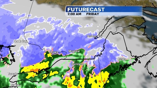
In Quebec City, Environment Canada is warning about possible snow squalls late in the day.
In Montreal, it will be windy with a forecasted high of 7 C, with the rain expected to continue until the afternoon.
Temperatures are expected to plummet by the evening, turning the rain back into snow, with a chance of isolated pockets of freezing rain during the transition.
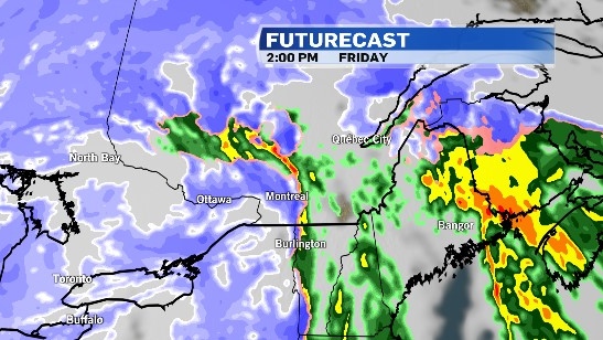
Strong winds gusting close to 70 km/h will cause blowing snow and reduced visibility.
"Plan your travel and allow extra time to get to your destination this holiday weekend as hazardous driving conditions are expected," Environment Canada said in the weather bulletin.
SATURDAY
By Saturday, snow squalls are possible over parts of southern Quebec as colder air sweeps over the Great Lakes.
Flurries are in the forecast with a high of -4 C under windy conditions. There's a 40 per cent chance of flurries into the evening, with a low of -7 C.
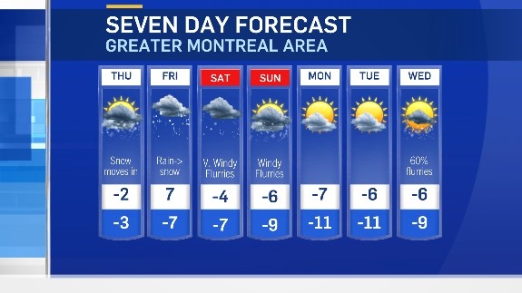
The high for Christmas Day is -6 C under cloudy skies with some flurries expected.
Strong winds and blowing snow will continue through the Christmas weekend.


CTVNews.ca Top Stories

From essential goods to common stocking stuffers, Trudeau offering Canadians temporary tax relief
Canadians will soon receive a temporary tax break on several items, along with a one-time $250 rebate, Prime Minister Justin Trudeau announced Thursday.
No evidence linking Modi to criminal activity in Canada: national security adviser
A senior official says the Canadian government is not aware of any evidence linking Indian Prime Minister Narendra Modi to alleged criminal activity perpetrated by Indian agents on Canadian soil.
Trump chooses Pam Bondi for attorney general pick after Gaetz withdraws
U.S. president-elect Donald Trump on Thursday named Pam Bondi, the former attorney general of Florida, to be U.S. attorney general just hours after his other choice, Matt Gaetz, withdrew his name from consideration.
Second Australian teen dies in tainted alcohol case in Laos that has killed 6 tourists
A second Australian teenager who fell critically ill after drinking tainted alcohol in Laos has died in a hospital in Bangkok, her family said Friday, bringing the death toll in the mass poisoning of foreign tourists to six.
A one-of-a-kind Royal Canadian Mint coin sells for more than $1.5M
A rare one-of-a-kind pure gold coin from the Royal Canadian Mint has sold for more than $1.5 million. The 99.99 per cent pure gold coin, named 'The Dance Screen (The Scream Too),' weighs a whopping 10 kilograms and surpassed the previous record for a coin offered at an auction in Canada.
More than 70K Murphy beds recalled across Canada, U.S. over tipping concerns
A popular series of Murphy beds that had been sold online is under a recall in Canada and the U.S. after several reported instances of the furniture detaching from walls.
She thought her children just had a cough or fever. A mother shares sons' experience with walking pneumonia
A mother shares with CTVNews.ca her family's health scare as medical experts say cases of the disease and other respiratory illnesses have surged, filling up emergency departments nationwide.
Meta fights CRTC, refuses to publicly release info on news blocking measures
Meta is refusing to publicly disclose information that could determine whether it is subject to the Online News Act despite blocking news from its platforms.
opinion
opinion Trump's cabinet picks: Useful pawns meant to be sacrificed to achieve his endgame
In his column for CTVNews.ca, Washington political analyst Eric Ham argues U.S. president-elect Donald Trump's controversial cabinet nominees are useful pawns meant to be sacrificed for a more bountiful reward down the line.
Shopping Trends
The Shopping Trends team is independent of the journalists at CTV News. We may earn a commission when you use our links to shop. Read about us.


Toronto
-

'Not good for the economy': MPs call on federal government to regulate resale concert tickets
Ticket fraud and sky-high prices for Taylor Swift concerts have some politicians calling for changes to the way tickets are sold in Canada.
-
Toronto Santa Claus Parade organizers 'optimistic' after funding comes in for 2025 event
The organizers of Toronto’s Original Santa Claus Parade are hopeful that the Jolly Old Elf will be coming to town for years to come.
-
North York shooting sends man to hospital
A man has been rushed to the hospital following a shooting in North York Thursday night.
Ottawa
-
 NEW THIS MORNING
NEW THIS MORNING What's happening in Ottawa this weekend: Nov.22-24
Santa Claus visits Kanata, Kingston and Arnprior, Christmas market season gets underway and the Vanier Cup is at Queen’s University. CTVNewsOttawa.ca looks at things to do in Ottawa and eastern Ontario this weekend.
-
uOttawa to reconsider participation in U-Pass if city increases student fares, student union says
The student union at the University of Ottawa says it will consider pulling its participation from the U-Pass, which provides discounted transit fares for students, if the city goes forward with hiking student transit fees and violating the program’s contract.
-
Abdi inquest: Arresting officer feared for his safety during deadly arrest, jurors hear
A former Ottawa police officer returned to the witness stand on Monday and provided further details of the moments before the violent and deadly arrest of Abdirahman Abdi on the fourth day of a coroner's inquest into the circumstances of his death.
Atlantic
-

CTV News Roundtable: N.S. leaders discuss solutions on affordability, housing, health care
Nova Scotia’s top three political party leaders took part in CTV Atlantic’s roundtable discussion on Thursday, where they sparred over affordability, housing, health care, and campaign promises.
-
From essential goods to common stocking stuffers, Trudeau offering Canadians temporary tax relief
Canadians will soon receive a temporary tax break on several items, along with a one-time $250 rebate, Prime Minister Justin Trudeau announced Thursday.
-
'This is cold': P.E.I. mother upset over decision to remove late daughter's photos from school memorial wall
A high school on Prince Edward Island is removing pictures of its late students from a memorial wall – a decision that has upset one mother whose daughter attended the school.
N.L.
-

As N.L. firm pivots, scientists say Canada's green hydrogen dreams are far-fetched
A Newfoundland energy company's embrace of data centres is raising doubts about eastern Canadian hopes of harnessing the region's howling winds to supply Germany with power from green hydrogen.
-
Canadian leads group pushing Vatican for zero-tolerance policy on abuse by clergy
An international group led by a Canadian is in Rome this week to push the Catholic Church to adopt a zero-tolerance policy on abuse by clergy.
-
Newfoundland wind-to-hydrogen company eyes data centre as international market lags
A company hoping to build a multi-billion-dollar wind-to-hydrogen project in western Newfoundland is eyeing other options as Canada's plans to supply Europe with green energy have not yet materialized.
Northern Ontario
-

Province cancels deal with Canadore College for North Bay addiction treatment centre
After years of delays, the province has pulled the plug on an addiction treatment centre in North Bay. A news release from Canadore College on Thursday confirmed the centre won’t be moving forward.
-
From essential goods to common stocking stuffers, Trudeau offering Canadians temporary tax relief
Canadians will soon receive a temporary tax break on several items, along with a one-time $250 rebate, Prime Minister Justin Trudeau announced Thursday.
-
$3M donation to help repair arena in Elliot Lake
The City of Elliot Lake said Thursday it has received a $3-million donation from Edward and Suzanne Rogers for the Centennial Arena restoration.
Kitchener
-

LRT train knocked off its tracks after slamming into car
A crash between an LRT train and car shut down a busy Kitchener street for more than eight hours on Thursday.
-
FunGuyz says it's closing all 30 of its magic mushroom stores in Ontario
FunGuyz, which calls itself the biggest magic mushroom dispensary in Canada, says it's shutting down all 30 of its Ontario locations.
-
Fight between rival motorcycle gangs in Cambridge leads to five arrests, more than a dozen charges
A fight between rival outlaw motorcycle gangs has led to multiple arrests, more than a dozen charges and the seizure of 17 firearms.
Windsor
-

Ont. law firm seeks information on convicted Catholic priest amid active abuse lawsuit
An Ontario law firm is seeking information about the movements and activities of a Catholic priest who was convicted of sexually abusing a 12-year-old boy before he died.
-
Sparky's Toy Drive on the hunt for a new home
They’ve been based out of the basement of Hotel Dieu Grace Healthcare for many years, rent free - however, that partnership is coming to an end.
-
Woman sought following serious assault in west Windsor
Windsor police are asking for the public’s help identifying a suspect wanted in connection to an alleged serious assault that happened this past summer.
Barrie
-

First university campus coming to Barrie
Just weeks after endorsing a plan set to bring a new sports field to the downtown core, there's another major shakeup on the horizon.
-
'You can't be lazy on my watch,' Court hears audio recordings in trial of alleged traffickers
The Crown played audio recordings in a Barrie courtroom Thursday afternoon that provided a glimpse into the lives of alleged human traffickers Lauriston and Amber Maloney and the group of young women who lived and worked for them.
-
How to avoid the number one cause of lung cancer in non-smokers, according to health experts
Radon is the number one cause of lung cancer in non-smokers in Canada, according to Grey Bruce Public Health Unit.
Vancouver
-

Vancouver police ignore FOI requests for chief's communications
For nearly a year, the Vancouver Police Department has failed to fulfill two freedom of information requests seeking records from Chief Adam Palmer and other high-ranking officials – a situation transparency advocates call highly concerning, and potentially illegal.
-
B.C. Conservatives roll out shadow cabinet and leadership roles for all 44 caucus members
All 44 members of the B.C. Conservative caucus have been appointed to leadership positions – whether as shadow cabinet members or Opposition house leader.
-
Vancouver youth soccer coach says racism complaint went uninvestigated for a year
The coach of a soccer team in the Vancouver Youth Soccer Association claims a complaint about racism directed at 13-year-old players on his team went unaddressed for more than a year.
Vancouver Island
-

Major crime investigators reviewing death of Victoria teen, which coroner reclassified as homicide
Vancouver Island’s major crime unit is investigating the case of a Victoria teenager whose death was initially ruled an accidental overdose, but has since been reclassified by coroners as a homicide.
-
B.C. Conservatives roll out shadow cabinet and leadership roles for all 44 caucus members
All 44 members of the B.C. Conservative caucus have been appointed to leadership positions – whether as shadow cabinet members or Opposition house leader.
-
1 dead after Nanaimo house fire, RCMP say
One person is dead after a fire that destroyed a home in Nanaimo's south end Wednesday morning.
Winnipeg
-

Sio Silica plans to try again with controversial project in Manitoba
Sio Silica is planning to try again with a controversial mining project in the same spot using the same method that the province rejected less than a year ago, but this time with more community engagement.
-
'We need new revenue': Winnipeg projecting operating shortfall by end of 2024
The City of Winnipeg is projecting an operating shortfall in 2024, and the plan to cover it off would completely drain the city's rainy day fund.
-
Manitoba RCMP issue Canada-wide warrant for Ontario semi-driver charged in deadly crash
Manitoba RCMP have issued a Canada-wide arrest warrant for the semi-driver involved in a crash that killed an eight-year-old girl and her mother.
Calgary
-

Calgary Fire Department responding to explosion in Mahogany
The Calgary Fire Department responded to an explosion and fire at a six-plex in the city's southeast on Thursday afternoon.
-
A tax break and cut cheques: Ottawa announces relief plan for cash-strapped Canadians
It's an announcement meant to appeal to cash-strapped Canadians—a tax break impacting everything from groceries to children's clothes to diapers—and it will last for two months.
-
'It was horrendous': Calgary family traumatized after vicious dog attack in northwest
A Calgary family is warning others and wants to see more accountability for pet owners after their dog was attacked and seriously injured in the northwest community of Royal Oak.
Edmonton
-

Alberta pitches new rules for auto insurance, including rate hikes, no-fault claims
The Alberta government is making changes to auto insurance, including rate hikes and switching to a predominantly no-fault claims model.
-
Cartmell, Caterina running to be Edmonton's next mayor
Two city councillors, one sitting and one former, will be running for mayor in 2025.
-
A tax break and cut cheques: Ottawa announces relief plan for cash-strapped Canadians
It's an announcement meant to appeal to cash-strapped Canadians—a tax break impacting everything from groceries to children's clothes to diapers—and it will last for two months.
Regina
-

Accused of sexual assault, Regina chiropractor takes the stand as first defense witness
A Regina chiropractor accused of sexually assaulting seven different women took the stand Thursday as arguments began in his defense.
-
Contractor fatally injured while on the job at Regina's Evraz plant
Evraz North America says an investigation is underway after a contractor was fatally injured while on the job in Regina on Nov. 19.
-
'I'll always be a Pat': Regina Pats trade captain Tanner Howe to Calgary
The Regina Pats have announced a blockbuster trade Thursday that sees captain Tanner Howe on his way to Calgary to play for the Hitmen as the team continues rebuilding for the future.
Saskatoon
-

Sask. principal has sexual assault conviction overturned in light of 'butt-grabbing game'
A Saskatchewan principal convicted to six months behind bars for sexual assault has another chance to prove he’s the victim of a middle-school prank that escalated out of control.
-
Saskatoon's first female mayor sworn in
After being sworn in Wednesday night alongside a mix of new and returning city councillors, Cynthia Block becomes the first female mayor of Saskatoon.
-
Sask. tuxedo business closes stores across the province
A Saskatchewan tuxedo business says struggles with inflation and operating costs have caused it close stores across the province.