Here we go again: Humidex could rise to nearly 40 degrees in Montreal, southern Quebec this week
Montreal -
We’re not out of it yet, Quebec.
Through the week, high temperatures will return as another sticky mass of hot air sweeps the province, pushing humidex levels towards a perceived 40 degrees in some areas.
A special weather advisory is in place for the following areas:
- Montréal Island area
- Châteauguay - La Prairie area
- Laval area
- Longueuil - Varennes area
“Temperatures will approach 30 degrees Celsius and humidex values could reach 40 on the hottest days, Friday and Saturday,” reads the advisory from Environment Canada.
“In addition, the nights will be uncomfortable, with lows near 20 degrees Celsius from Wednesday through Monday.”
Young children, pregnant women, the elderly, persons with chronic underlying medical conditions and those working or exercising outdoors are at elevated risks of heat stroke and exhaustion.
“Drink lots of water, even before feeling thirsty, and keep cool,” reads the weather advisory.
 The high for Wednesday is expected to reach 28 C. (Lori Graham/CTV News)
The high for Wednesday is expected to reach 28 C. (Lori Graham/CTV News)
WEEK FORECAST
Here’s how the next few days will look across the affected regions:
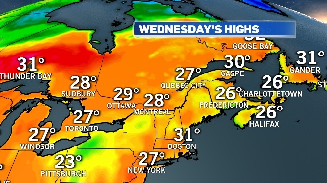
A high of 28 could feel more like 37 degrees with the humidex on Wednesday.
A risk of thunderstorms is maintained through the morning, with a risk of showers continuing into the evening.
A UV index of 6, which is considered high, is expected to continue through to Thursday at least.
On Thursday, the 27 high could feel more like 35. Cloudy conditions will bring a 30 per cent chance of showers.
Friday should be sunny, with a high of 31 degrees.
The clouds and showers are expected to return over the weekend, with temperatures expected to approach 30 degrees.
HIGH TEMPERATURES COULD MARK SECOND HEATWAVE FOR AUGUST
An official heatwave is defined as three consecutive days with daytime highs at or above 30.
Montreal saw its first official heat wave of the year last week with five straight days of highs above the 30 degree mark.
The city has recorded a total of 15 30 degree days so far this summer: three in May, five in June, one in July and six in August.
Summer 2020 saw the mercury climb above 30 a total of 25 times: twice in May, eight times in June, 14 times in July and once in August.
The city normally sees an average of nine 30 degree days per year.
The record for the most 30 degree days is 33 set in 1955.


CTVNews.ca Top Stories

Police ID mom, daughter killed in Old Montreal; video shows person break into building before fatal fire
The identities have been released of the mother and daughter who were killed after a fire tore through a 160-year-old building in Old Montreal on Friday.
Tropical Storm Milton forms in Gulf of Mexico, could intensify as a hurricane threatening Florida
Tropical Storm Milton has formed in the Gulf of Mexico. It is located 220 miles (355 kilometres) north-northeast of Veracruz, Mexico.
'I screamed in shock and horror': Family faces deadly Vancouver hit-and-run driver during sentencing
The sentencing of the man who pleaded guilty in the deadly hit-and-run in Kitsilano two years ago began on Friday.
Frequent drinking of fizzy beverages and fruit juice are linked to an increased risk of stroke: research
New data raises questions about the drinks people consume and the potential risks associated with them, according to researchers at Galway University in Ireland, in partnership with Hamilton’s McMaster University.
Northwestern Ont. woman charged with arson with disregard for human life
A 30-year-old northwestern Ontario woman has been charged with arson following a structure fire Thursday night, police say.
OPP charge driver going 175 km/h on Highway 417 in Ottawa
Ontario Provincial Police have laid stunt charges against a driver caught speeding 75 km/h over the speed limit on Highway 417 in Ottawa's west end.
Looking for cheap flights for the holidays? Here are some tips to remember
Travelling on a budget can be stressful, but there are ways you can ensure you're getting the best deal on flights as the holiday season approaches.
A French judge in a shocking rape case allows the public to see some of the video evidence
A French judge in the trial of dozens of men accused of raping an unconscious woman whose now former husband had repeatedly drugged her so that he and others could assault her decided on Friday to allow the public to see some of the video recordings of the alleged rapes.
The Menendez brothers case is not the only one that's been affected by a true crime documentary
Being an armchair detective has turned into an American obsession, fueled by an abundance of true-crime content in podcasts and television series. But some of those projects have sparked actual legal developments.
Shopping Trends
The Shopping Trends team is independent of the journalists at CTV News. We may earn a commission when you use our links to shop. Read about us.


Toronto
-

Officer arrested after allegedly stealing alcohol from store: TPS
A Toronto police officer has been arrested after allegedly stealing three bottles of alcohol from a store.
-
Two pedestrians taken to hospital after Vaughan crash, one person in custody
Two pedestrians have been taken to hospital with serious injuries after an early-morning collision in Vaughan.
-
Nuit Blanche takes over Toronto tonight. Here is what you need to know about road closures and TTC service
Toronto’s annual Nuit Blanche is back and with it come road closures.
Ottawa
-

This Ottawa photo radar camera issued 200 tickets a day over the summer
New data shows the automated speed enforcement camera on King Edward Avenue, between Bolton Street and St. Patrick Street, issued 6,337 speeding tickets in August, the highest number of tickets issued by Ottawa's 40 photo radar cameras.
-
Frost advisory issued with temperatures expected to drop near freezing in Ottawa
Environment Canada has issued a frost advisory as temperatures across Ottawa and eastern Ontario are expected to dip near the freezing mark this evening.
-
Looking for cheap flights for the holidays? Here are some tips to remember
Travelling on a budget can be stressful, but there are ways you can ensure you're getting the best deal on flights as the holiday season approaches.
Atlantic
-

Battle between activist candidate and ex-Tory reflects schism in N.B. politics
A riding in southwest New Brunswick that for decades was a Progressive Conservative stronghold is shaping up to be a bellwether that could offer a window into the future of the Tory party, and maybe of the province.
-
Tropical Storm Milton forms in Gulf of Mexico, could intensify as a hurricane threatening Florida
Tropical Storm Milton has formed in the Gulf of Mexico. It is located 220 miles (355 kilometres) north-northeast of Veracruz, Mexico.
-
Latest book from Nova Scotia author Allison Maher is a surprising first entry into adult fiction
Nova Scotia author Allison Maher made the jump from young adult (YA) to adult fiction with her most recent novel, “The Last of the Firsts” and the response from readers has been a surprise for the writer.
N.L.
-

Marathon goat: Animal runner wins hearts and a medal after crashing Newfoundland race
He may not have logged the fastest time or even gone the full distance, but residents of a Newfoundland town agree the goat who unexpectedly joined the local weekend half marathon was the event's undisputed champion.
-
Labrador residents say 'inhumane' food prices force families to go hungry
A mother in a community where the cost of living is one of the highest in the country says grocery prices are 'inhumane' and retailers are putting profits ahead of people’s basic human right to food.
-
Small English soccer team has huge year, thanks in part to Newfoundland and Labrador
A soccer game in England on Tuesday night drove a spike in online traffic across the Atlantic to a website launched by the Newfoundland and Labrador government.
Northern Ontario
-

Canadian musician Jacob Hoggard found not guilty of sexual assault
Canadian musician Jacob Hoggard has been found not guilty of sexually assaulting a young woman in northeastern Ontario eight years ago. The former Hedley frontman had pleaded not guilty to sexual assault.
-
Police ID mom, daughter killed in Old Montreal; video shows person break into building before fatal fire
The identities have been released of the mother and daughter who were killed after a fire tore through a 160-year-old building in Old Montreal on Friday.
-
No injuries reporter in Greater Sudbury garage fire
Fire crews in Greater Sudbury battled a large garage fire on Friday.
London
-

'We've got to get them home'; Organization continues search for missing London Ont. women
An organization who has assisted in locating 40 missing people since 2018, has its sights set on the Thames River near Cavendish Park in London, Ont.
-
One injured in plane crash near Brussels
Huron OPP say they were on the scene of a plane crash this morning, with a pilot finding themselves unable to halt before the end of a runway in Brussels.
-
Tax rebate: Canadians with low to modest incomes to receive payment
Canadians who are eligible for a GST/HST tax credit can expect their final payment of the year on Friday.
Kitchener
-

One injured after small plane crash lands in Brussels
The Huron Ontario Provincial Police said they responded to a “downed airplane” just after 11 a.m. Saturday.
-
One person sprayed with 'noxious substance' in Cambridge
Police say they were called to the area of Simcoe Street and Market Street around 1:30 a.m. Saturday for a report of an assault.
-
Urgent call for volunteers for Oktoberfest parade
The Oktoberfest Parade is fast approaching and organizers are urgently seeking volunteers to fill the role of sign carriers.
Windsor
-

Leamington business and property owners fined $10,000 for fire code violations
The municipality issued a stern reminder for code violators, as both were fined following a warning issued by Leamington Fire Services.
-
Man wanted for vandalism in Windsor
According to police, the suspect entered and vandalized the property in the 700 block of Grand Marais Road Easton on September 28.
-
Looking for cheap flights for the holidays? Here are some tips to remember
Travelling on a budget can be stressful, but there are ways you can ensure you're getting the best deal on flights as the holiday season approaches.
Barrie
-

Police search for missing Orillia man
OPP are seeking assistance in their search for a 30-year-old man last seen in Orillia.
-
Hockey equipment drive begins deliveries to Indigenous communities
After collecting around a thousand bags of donated hockey equipment and 2,000 sticks since April, Saturday's Indigenous Hockey Equipment Drive in Barrie began delivering to youth in need across 15 Indigenous communities across Ontario.
-
Drug trafficking investigation leads to seizure of weapons and stolen property: OPP
Three people from Simcoe County face charges in relation to a drug trafficking investigation that police say resulted in the seizure of several weapons, drugs and thousands of dollars worth of stolen property.
Vancouver
-

Crews battle massive fire in Langley city Saturday
Fire crews battled a massive blaze in downtown Langley Saturday morning.
-
2nd-degree murder charge laid nearly 2 years after Kelowna stabbing
Nearly two years after a man was stabbed to death in downtown Kelowna, RCMP have made an arrest in the case.
-
Murder suspect arrested in Mackenzie, B.C., RCMP say
The man suspected of murdering another man inside a Mackenzie, B.C., home last weekend has been arrested.
Vancouver Island
-

B.C. campaign trail sees party leaders head to the Okanagan
The leaders of both British Columbia's provincial Conservatives and New Democrats are in the Okanagan campaigning today.
-
Teachers' union wants education focus in B.C.'s 2024 election
We haven't heard the candidates talk much about education during B.C.'s 2024 election campaign, but the teachers' union is trying to put the spotlight on that issue.
-
Missing B.C. climber died from fall on Mount Baker, medical examiner says
The body of a British Columbia mountain climber has been located and recovered after the 39-year-old man was reported missing during a solo climb on Washington state's Mount Baker earlier this week.
Winnipeg
-

'Great fun in this': Giant roadside attractions across Manitoba highlighted online
It’s 1998. Google was just born, and dial-up was the primary way to connect to the Internet. New sites were being developed daily on any number of topics, from recipes to shopping. David Yanciw, however, was thinking big - big things, that is.
-
Glenwood house under construction set ablaze Saturday
A two-storey house that was under construction was the scene of a Saturday morning fire in Winnipeg’s Glenwood neighbourhood.
-
STARS, emergency crews dispatched to crash on Highway 12 in Brokenhead
Highway 12 has been reopened following a single motor vehicle collision Saturday morning in the RM of Brokenhead, Man.
Calgary
-

Investigation underway into Friday night fatal collision in southeast Calgary
An investigation is underway into a Friday night collision in southeast Calgary that left one person dead.
-
Turner Valley RCMP on scene at vehicle rollover near Plummers Road
An investigation is underway into what caused a vehicle rollover Saturday in the area of Plummers Road and Priddis Valley Road.
-
B.C. Lions snuff out Calgary Stampeders playoff hopes with 32-15 win
The loss that extinguished the Calgary Stampeders playoff dreams Friday provided some deja vu for head coach Dave Dickenson.
Edmonton
-

'We're losing billion of birds': Backyard risks to Alberta's birds and how you can help make fall migration a successful one
An estimated four billion birds will navigate man-made environments as they travel south from North America during fall migration. Tens of million of them will die en route due to human-created hazards.
-
Woman dies in east Edmonton collision with building on 118 Avenue
A 79-year-old woman is dead after the vehicle she was driving crashed into an east Edmonton building late Friday afternoon.
-
Goaltender Jack Campbell enters NHL/NHLPA player assistance program
Detroit Red Wings goaltender Jack Campbell has entered the NHL/NHLPA player assistance program.
Regina
-

Wind warning in effect as strong gusts hammer Regina, southern Sask.
A wind warning has been issued for parts of southern Saskatchewan, with gusts of up to 100 kilometres per hour (km/h) possible in some areas on Saturday, Environment and Climate Change Canada says.
-
Regina police investigating after multiple homes shot at during overnight hours
Regina police are investigating after guns were fired at two homes last week, with one home being shot at on multiple occasions.
-
Sask. community marks sod-turning for Humboldt Broncos memorial
A permanent memorial at the site of the 2018 Humboldt Broncos bus crash is about to be a step closer.
Saskatoon
-

Sask. community marks sod-turning for Humboldt Broncos memorial
A permanent memorial at the site of the 2018 Humboldt Broncos bus crash is about to be a step closer.
-
Private school funding draws attention during STF education forum
The Saskatchewan Teachers' Federation hosted a virtual election forum on education Thursday evening, giving candidates in the provincial election a chance to share their thoughts and answer questions on issues teachers find most important.
-
Sask. man pleads guilty in U.S. after providing videos of men raping toddlers to FBI agent he thought was pedophile
A Saskatchewan man living in the United States has pleaded guilty to possessing child pornography after he unknowingly provided disturbing videos to an FBI agent he thought was a pedophile.