Summer's over: Strong storms, possible flooding bring an end to the hot weather
A storm system tracking into Quebec is expected to end the summery September heat.
Strong thunderstorms are expected to develop Tuesday afternoon as a cold front digs into the warm and humid air mass that has been sitting over parts of the province since the middle of last week.
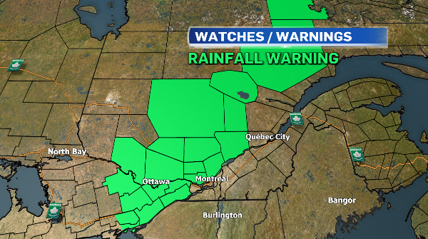
Environment and Climate Change Canada has issued rainfall warnings for most areas north of the Saint Lawrence River.
Heavy downpours could drop between 50 and 75 millimetres of rain through to Wednesday morning, potentially causing flash floods and pooling water on the roads.
The Ottawa Valley, Lachute-Saint-Jérôme, the Laurentians, Lanaudière and Mauricie are expected to see the heaviest rainfall.
Montreal and the rest of southwestern Quebec should brace for powerful thunderstorms, heavy downpours and strong winds from Tuesday afternoon to overnight.
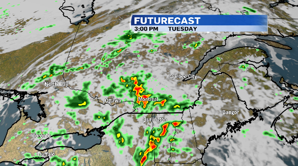
Once the cold front moves through, conditions are expected to dry out gradually on Wednesday, with temperatures starting to drop.
The overnight low in Montreal is expected to be in the single digits, with daytime highs below average for the end of the week as sunshine returns.

The weather system is expected to end the summery heat Montreal has been experiencing, with daytime highs in the upper 20 degrees Celsius and humidex values in the 30s.


CTVNews.ca Top Stories

B.C. tenants evicted for landlord's use after refusing large rent increase to take over neighbouring suite
Ashley Dickey and her mother rented part of the same Coquitlam duplex in three different decades under three different landlords.
Mountain guide dies after falling into a crevasse in Banff National Park
A man who fell into a crevasse while leading a backcountry ski group deep in the Canadian Rockies has died.
Expert warns of food consumption habits amid rising prices
A new survey by Dalhousie University's Agri-Food Analytics Lab asked Canadians about their food consumption habits amid rising prices.
MPP Sarah Jama asked to leave Ontario legislature for wearing keffiyeh
MPP Sarah Jama was asked to leave the Legislative Assembly of Ontario by House Speaker Ted Arnott on Thursday for wearing a keffiyeh, a garment which has been banned at Queen’s Park.
Charlie Woods, son of Tiger, shoots 81 in U.S. Open qualifier
Charlie Woods failed to advance in a U.S. Open local qualifying event Thursday, shooting a 9-over 81 at Legacy Golf & Tennis Club.
Ex-tabloid publisher testifies he scooped up possibly damaging tales to shield his old friend Trump
As Donald Trump was running for president in 2016, his old friend at the National Enquirer was scooping up potentially damaging stories about the candidate and paying out tens of thousands of dollars to keep them from the public eye.
Here's why provinces aren't following Saskatchewan's lead on the carbon tax home heating fight
After Prime Minister Justin Trudeau said the federal government would still send Canada Carbon Rebate cheques to Saskatchewan residents, despite Saskatchewan Premier Scott Moe's decision to stop collecting the carbon tax on natural gas or home heating, questions were raised about whether other provinces would follow suit. CTV News reached out across the country and here's what we found out.
Montreal actress calls Weinstein ruling 'discouraging' but not surprising
A Montreal actress, who has previously detailed incidents she had with disgraced Hollywood producer Harvey Weinstein, says a New York Court of Appeals decision overturning his 2020 rape conviction is 'discouraging' but not surprising.
Caleb Williams, Jayden Daniels and Drake Maye make it four NFL drafts with quarterbacks going 1-3
Caleb Williams is heading to the Windy City, aiming to become the franchise quarterback Chicago has sought for decades.
Shopping Trends
The Shopping Trends team is independent of the journalists at CTV News. We may earn a commission when you use our links to shop. Read about us.


Toronto
-
Suspect, 3 persons of interest sought after man falls to death from downtown Toronto balcony
Toronto police say the homicide unit is investigating after a man was reportedly pushed to his death from a balcony downtown late Wednesday night.
-
MPP Sarah Jama asked to leave Ontario legislature for wearing keffiyeh
MPP Sarah Jama was asked to leave the Legislative Assembly of Ontario by House Speaker Ted Arnott on Thursday for wearing a keffiyeh, a garment which has been banned at Queen’s Park.
-
Man shot and killed in violent home invasion at Etobicoke townhouse, police say
Toronto police say they are searching for three suspects after a man was shot and killed inside an Etobicoke townhouse during what investigators have described as a violent home invasion.
Ottawa
-
 NEW THIS MORNING
NEW THIS MORNING The Almonte Hospital's mystery March baby boom
This spring has been full of life in Almonte, as the local hospital has seen its biggest baby boom in recent memory.
-
NEW THIS MORNING
NEW THIS MORNING What's happening in Ottawa this weekend: April 26-28
CTVNewsOttawa.ca looks at things to do in Ottawa during the final weekend of April.
-
Criminal charge laid in 2023 hedge trimming death; company owner pleads guilty to Ministry of Labour charge
The supervisor of a 20-year-old man who died after he was electrocuted while trimming hedges in Manotick in May 2023 has been charged with criminal negligence causing death. Meanwhile, the company owner has pleaded guilty to a charge laid by the Ministry of Labour.
Atlantic
-

'They followed their gut': N.B. RCMP say wellbeing check led to rescue of human trafficking victims
The New Brunswick RCMP say a wellbeing check that led to the rescue of three women from alleged human trafficking in Moncton earlier this month was the result of someone following their gut.
-
2 teens charged in Halifax homicide: police
Two teenagers have been charged with second-degree murder in connection to an alleged homicide near the Halifax Shopping Centre earlier this week.
-
N.S. residents arrested at New Brunswick border with multiple weapons
Canadian Border Services Agency (CBSA) officers arrested two Nova Scotia residents at the New Brunswick border after they seized multiple prohibited firearms.
N.L.
-

Made-in-Newfoundland vodka claims top prize at worldwide competition
A Newfoundland-made vodka has been named one of the world’s best by judges at this year’s World Vodka Awards.
-
Rideshare platform Uber expands to Newfoundland and Labrador
Uber Technologies Inc. says it has brought its ridesharing platform to Newfoundland and Labrador.
-
Newfoundland director found creeping terror of 'The King Tide' in a tiny coastal town
Newfoundlander Christian Sparkes has shot several films around his home province, but with his new psychological thriller 'The King Tide' he saw an opportunity to wander into one unique town that had eluded him over the years.
Northern Ontario
-

Former head of Ont. tech company charged in $6M fraud case
A years-long fraud investigation by the Ontario Provincial Police’s anti-rackets branch has resulted in fraud and other charges for the former head of BioNorth Technology Group, Frank Benincasa
-
Secret $70M Lotto Max winners break their silence
During a special winner celebration near their hometown, Doug and Enid shared the story of how they discovered they were holding a Lotto Max ticket worth $70 million and how they kept this huge secret for so long.
-
Fire victims in Timmins say thieves have stolen their personal belongings
A month after an accidental fire forced more than 100 people out of their apartments at the Empire Complex in Timmins, residents are now dealing with being victims of theft.
London
-

Fatal crash closes section of Highway 401
A fatal crash in Thames Centre has closed down a portion of Highway 401 westbound. Around 2:15 a.m., first responders were called to westbound lanes of the highway between Culloden and Putnam Roads for a two-vehicle crash.
-
Tentative agreement reached between GTAs and Western
The union representing western's graudate teacher's assistants says a tentative agreement has been reached with the university.
-
Free parking may return to London’s core area business districts
Just weeks after a COVID-era parking promotion ended, a pared-down free parking program may soon launch in its place.
Kitchener
-

Generational farm could be impacted if Wilmot land assembly goes ahead
A family of farmers say their operations would be significantly impacted if the Region of Waterloo goes ahead with a land assembly project in the Wilmot Township area.
-
Former Kitchener doctor accused of sexually assaulting patients makes brief court appearance as marathon trial continues
The trial for former neurologist Jeffrey (Scott) Sloka began two and a half years ago, and it remains unclear when there may be a verdict.
-
Drivers who got bad fuel from Guelph, Ont. gas station receiving compensation
Drivers who were hit with hefty repair bills after fueling up at a Guelph gas station appear to be finally getting their money back.
Windsor
-

'A slap in the face': Foreign workers still building NextStar battery plant in Windsor: CBTU
Canada’s Building Trades Unions is demanding the federal government intervene as it alleges local workers are being “sidelined” by foreign employees.
-
Oversized danger: pedestrian advocacy groups call for smaller trucks and SUVs
A coalition of 60 pedestrian and cycling safety advocacy groups is calling for government regulation and auto industry changes after data showed the dangers caused by large trucks and SUVs towards pedestrians.
-
Fatal crash closes section of Highway 401
A fatal crash in Thames Centre has closed down a portion of Highway 401 westbound. Around 2:15 a.m., first responders were called to westbound lanes of the highway between Culloden and Putnam Roads for a two-vehicle crash.
Barrie
-

Honda unveils $15B investment plan to build new EV plant in Alliston
Prime Minister Justin Trudeau and Premier Doug Ford visited Alliston on Thursday to unveil a $15 billion investment in an electric vehicle and battery facility.
-
Secret $70M Lotto Max winners break their silence
During a special winner celebration near their hometown, Doug and Enid shared the story of how they discovered they were holding a Lotto Max ticket worth $70 million and how they kept this huge secret for so long.
-
One person charged following shootings in Bradford
One person has been charged following a series of shootings in August and September in Bradford West Gwillimbury.
Vancouver
-

Vancouver developer apologizes for housing scandal at Little Mountain
It’s arguably the biggest social housing scandal in Vancouver’s history and today the developer responsible for the Little Mountain project apologized for the multi-year delay that’s left a massive plot of land vacant during a housing crisis.
-
'So shocking': Roommate of victim left reeling after fatal White Rock stabbing
The roommate and long-time friend of the young man who was killed in White Rock Tuesday night, says he’s still in disbelief over what happened.
-
Inquest into B.C. police shooting deaths recommends emergency events be recorded
An inquest jury looking into the police shooting deaths of a man and the woman he was holding hostage has recommended that events involving the emergency response team be recorded with both video and audio.
Vancouver Island
-

Hiker airlifted to hospital in critical condition after falling into Vancouver Island canyon
A hiker was airlifted to hospital in critical condition Tuesday after he fell approximately 60 metres into a canyon on Vancouver Island.
-
B.C. civil lawsuit against Sex Pistols guitarist alleges 1980 sexual assault
A Vancouver woman has filed a civil lawsuit against Paramount Pictures Corp. and punk rocker Stephen Jones of The Sex Pistols alleging he sexually assaulted her as a teenager while she was a movie extra more than 40 years ago.
-
Harbour Air commits to buying 50 electric engines for seaplane fleet
Harbour Air is travelling towards a more sustainable future, looking to electrify its fleet of 45 aircraft.
Winnipeg
-

'Deep ignorance': Calls for Manitoba trustee to resign sparked after comments about Indigenous people and reconciliation
A rural Manitoba school trustee is facing calls to resign over comments he made about Indigenous people and residential schools earlier this week.
-
Former Manitoba premier Heather Stefanson leaving politics after 23 years
Former Manitoba premier Heather Stefanson is resigning her legislature seat and leaving political life.
-
Arrest made in 2021 northern Manitoba double homicide: RCMP
Manitoba RCMP have arrested a suspect in relation to a 2021 double homicide in a remote northern community.
Calgary
-

Calgary CO call in Brentwood sends 7 people to hospital
Seven people were taken to Calgary hospitals on Thursday for carbon monoxide exposure.
-
Calgary financial advisor charged after allegedly embezzling nearly $5M
A Calgary man who worked as a senior financial advisor has been charged with fraud and theft after police say he misappropriated nearly $5 million from his clients.
-
Mountain guide dies after falling into a crevasse in Banff National Park
A man who fell into a crevasse while leading a backcountry ski group deep in the Canadian Rockies has died.
Edmonton
-

UCP able to remove councillors and axe city bylaws in new sweeping bill aimed at municipal politics
The Government of Alberta wants to change how municipalities handle elections and local politics.
-
Oilers 'far superior' to Kings when they're on top of their game: analyst
It's a travel day for the Edmonton Oilers — and some of their fans are along for the ride.
-
Experts urge Albertans to check measles vaccine status after confirmed Edmonton case
A confirmed case of measles in Edmonton has prompted another plea from health officials for people to make sure vaccinations are up to date.
Regina
-

RCMP make 2 arrests in connection to Oxbow area homicide
Saskatchewan RCMP have made two arrests in a homicide investigation in the province's southeast.
-
'Get these doctors here': Sask. family calls on province to step up gastroenterologist recruitment
The Weber family is being forced to travel to Toronto due to a lack of pediatric gastroenterologists (GIs) in the province. The family’s situation was highlighted by Saskatchewan’s official opposition.
-
Looking ahead to the upcoming CFL Draft
The draft will take place on Tuesday, April 30, the Saskatchewan Roughriders currently hold the third overall pick.
Saskatoon
-

Crown argues for life sentence for Sask. Mountie who shot and killed his lover
A Crown prosecutor says the former RCMP officer who shot and killed his lover should be sentenced to life in prison.
-
'Difficult to maintain': Private Sask. school embroiled in abuse allegations may soon close
A private Christian school at the centre of a civil lawsuit and several criminal cases might soon be taken over by an affiliated group, according to a letter obtained by CTV News.
-
Council votes for bike safety improvements at corner where cyclist was killed
Saskatoon city council is making road safety improvements following the death of a cyclist at a busy intersection last year.