Temperatures in Montreal to plummet after warm start to the week
 (Lillian Roy / CTV Montreal)
Following an exceptionally warm April day on Tuesday, temperatures are set to drop on Wednesday.
A sharp cold front sweeping across Quebec should drop temperatures rapidly throughout the day, with some areas possibly seeing rain change to wet snow.
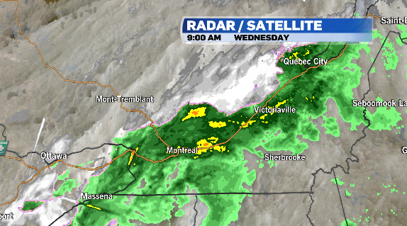
Environment and Climate Change Canada has issued flash freeze warnings east of Quebec City, including the Charlevoix region.

Temperatures are expected to drop by 10 degrees, causing puddles to freeze.
Surfaces such as highways and sidewalks may become icy and slippery.
A blowing snow advisory is in place over parts of the Gaspé Peninsula, where heavy snow and strong winds could combine and reduce visibility on the roadways.
Accumulations are expected over eastern regions of the province.
In Montreal, winds could shift to the north, increasing to 30 to 50 km/h.
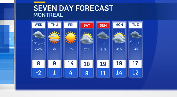
The temperature is expected to drop by over 20 degrees from Tuesday afternoon.
The temperature should drop to -2 degrees Celsius Wednesday night, down from Tuesday's high of 19.5 C.
The normal daytime high for April 24 in Montreal is 13 C, while the low is 3 C.
Sunshine is expected to return Wednesday afternoon.

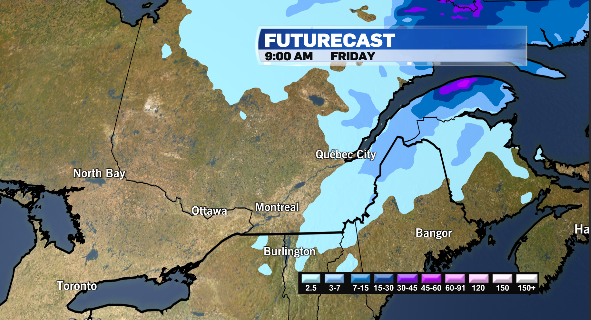
Temperatures should warm back up to seasonal by Friday, with milder air expected for the weekend.


CTVNews.ca Top Stories

Grandparents killed in wrong-way crash on Hwy. 401 identified
A 60-year-old man and a 55-year-old woman killed in a wrong-way crash on Highway 401 earlier this week have been identified by the Consulate General of India in Toronto.
Golf season a summer tourism driver in Canada
Golf is a sign of spring and summer and a major driver for seasonal tourism, experts say.
The kids from 'Mrs. Doubtfire are all SUPER grown up now, and we're not OK
The adorable trio of child actors from the 1993 classic comedy 'Mrs. Doubtfire,' which starred the late and great Robin Williams, are all grown up and looking back on their seminal time together.
Parliamentary report on Emergencies Act decision is 18 months past due — and counting
The erstwhile group of senators and MPs studying the federal government's invocation of the Emergencies Act over the "Freedom Convoy" was supposed to present its findings in December. December of 2022, that is.
Quebec man who threatened Trudeau, Legault online sentenced to 20 months in jail
A Quebec man who pleaded guilty to threatening Prime Minister Justin Trudeau and Premier François Legault has been sentenced to 20 months in jail.
Britney Spears 'home and safe' after paramedics responded to an incident at the Chateau Marmont, source tells CNN
A source close to singer Britney Spears tells CNN that the pop star is 'home and safe' after she had a 'major fight' with her boyfriend on Wednesday night at the Chateau Marmont in West Hollywood.
TD worst-case scenario more likely after drug money laundering allegations: analyst
TD Bank Group could be hit with more severe penalties than previously expected, says a banking analyst after a report that the investigation it faces in the U.S. is tied to laundering illicit fentanyl profits.
Police arrest 3 Indian nationals in killing of B.C. Sikh activist Hardeep Singh Nijjar
Three people have been arrested and charged in the killing of B.C. Sikh activist Hardeep Singh Nijjar – as authorities continue investigating potential connections to the Indian government.
Canadian doctor concerned new weight-loss drug Wegovy may be used inappropriately
As Wegovy becomes available to Canadians starting Monday, a medical expert is cautioning patients wanting to use the drug to lose weight that no medication is a ''magic bullet,' and the new medication is meant particularly for people who meet certain criteria related to obesity and weight.
Shopping Trends
The Shopping Trends team is independent of the journalists at CTV News. We may earn a commission when you use our links to shop. Read about us.


Toronto
-

Police officer hit by driver of fleeing vehicle in Toronto
York Regional Police say they are continuing to search for a suspect in an auto theft investigation who was captured on video running over a police officer in Toronto last month.
-
Grandparents killed in wrong-way crash on Hwy. 401 identified
A 60-year-old man and a 55-year-old woman killed in a wrong-way crash on Highway 401 earlier this week have been identified by the Consulate General of India in Toronto.
-
Video shows suspect setting Toronto-area barbershop on fire
Video of a suspect lighting a Richmond Hill barbershop on fire earlier this week has been released by police.
Ottawa
-
 NEW THIS MORNING
NEW THIS MORNING The pros and cons of discussing mental health issues in the workplace
A group of lawyers has written what they call a groundbreaking book about how mental health is perceived in the legal profession.
-
'He was the coolest kid': Remembering Griffin Bell ahead of CN Cycle for CHEO
Photographers will tell you that one of the best times to capture incredible images is just after sunrise or right before sunset. That time is known as the golden hour. It's the light that starts each day, offering hope and wonder about the day ahead. Griffin Bell exemplified that hope and light in a way that few others ever will.
-
Nighttime LRT construction derails east-end residents' sleep
Residents of an Orléans neighbourhood are voicing their frustration as overnight work on Stage 2 LRT causes disturbances for those living next to the construction site.
Atlantic
-
Police launch Mandatory Alcohol Screening program in Halifax area
An initiative called the Mandatory Alcohol Screening (MAS) program is designed to cut down on the number of drunk drivers on the road in the Halifax area.
-
'I have the will to live': N.B. woman needs double lung transplant
A New Brunswick woman suffering from sarcoidosis, a disease that limits your lung capacity, is in need of a double lung transplant.
-
Officers seize 28kg of elvers at N.S. holding facility
Fishery officers seized nearly 30 kilograms of elvers at a Yarmouth County, N.S., holding facility on Wednesday, arresting three people in the process.
N.L.
-

Funeral today for broadcasting legend and voice of 'Hockey Night in Canada' Bob Cole
A funeral is being held today for hockey broadcasting legend Bob Cole in his hometown of St. John's, N.L.
-
Newfoundland fisherman says police broke his leg during protest that delayed budget
Richard Martin is spending this year's fishing season on land after he says a Royal Newfoundland Constabulary officer broke his left leg in three places during a protest last month that shut down the provincial legislature.
-
'I feel honoured to say I was his friend': Wayne Gretzky remembers Bob Cole
Tributes continue to pour in for Bob Cole as his family has confirmed a funeral will be held for the legendary broadcaster Friday in St. John's, N.L.
Northern Ontario
-

Northern Ont. man guilty of three counts of first-degree murder in Sudbury firebombing
The jury deciding the fate of a man responsible for a fatal firebombing in Sudbury found him guilty of three counts of first-degree murder Friday afternoon.
-
Almost $17K in fines for illegal hunting, fishing in northern Ont.
Three men from southern Ontario and a man from Texas have been fined a total of $16,700 for illegal hunting and fishing in September 2021.
-
New Hamburg, Ont. family can't get truck's faulty transmission fixed due to aftermarket attachment
A New Hamburg family is feeling deflated after buying a new Toyota hybrid truck.
London
-
CTV News London's top stories from this week
In case you missed it, CTV News London has compiled all the top local stories from this week into one video for your convenience.
-
Soon to expire municipal funding would close 120-bed homeless shelter and return people to tents
Municipal funding is running out for a temporary shelter program that serves homeless Londoners.
-
Artworks that help heal
It looked like most other art exhibits, but the works on display at Fanshawe College were part of a healing process for the artists.
Kitchener
-

WRDSB to lay off 106 elementary school teachers
More than 100 teachers at the Waterloo Region District School Board (WRDSB) are learning they have been declared surplus will likely be out of a job as of Aug. 12.
-
Search underway for missing 17-year-old in Kitchener
There was a large police presence in a Kitchener neighbourhood Friday evening as officers searched for a missing 17-year-old.
-
Chemical spill could be cause of stinky water in Puslinch, Ont., new report says
People living in Puslinch, Ont. may have the answer to why their water smelled so bad last year.
Windsor
-

CTV News Windsor's top stories from this week
In case you missed it, CTV News Windsor has compiled all the top local stories from this week into one video for your convenience.
-
Grade 6 student saves choking classmate
A lesson learned at school saved a life Thursday.
-
Windsorites in store for warm but wet conditions this weekend
A wet and muggy start to the weekend is expected across Windsor-Essex.
Barrie
-

80-year-old Ont. man to face jury in historical sexual assault case involving children
A trial date has been set for an Ontario senior facing allegations of historical sexual offences involving children.
-
Bracebridge plant pauses operations after destructive fire
On Thursday night, 30 firefighters battled a destructive fire that broke out in a facility in Bracebridge Ont.
-
Driver charged with speeding while impaired on Hwy 11
A driver was handed a three-month licence suspension for allegedly speeding while impaired on Highway 11 in Muskoka.
Vancouver
-

Suter scores late goal, clinches series for Canucks
Pius Suter scored with 1:39 left and the Vancouver Canucks advanced to the second round of the NHL playoffs with a 1-0 victory over the Nashville Predators on Friday night in Game 6.
-
Former B.C. Mountie fined for hiring foreign nanny without work permit
A former Mountie who pleaded guilty to illegally employing a foreign national without a work permit has been ordered to pay a $2,000 fine and have no contact with her former nanny for two years.
-
Police arrest 3 Indian nationals in killing of B.C. Sikh activist Hardeep Singh Nijjar
Three people have been arrested and charged in the killing of B.C. Sikh activist Hardeep Singh Nijjar – as authorities continue investigating potential connections to the Indian government.
Vancouver Island
-
Suter scores late goal, clinches series for Canucks
Pius Suter scored with 1:39 left and the Vancouver Canucks advanced to the second round of the NHL playoffs with a 1-0 victory over the Nashville Predators on Friday night in Game 6.
-
Police arrest 3 Indian nationals in killing of B.C. Sikh activist Hardeep Singh Nijjar
Three people have been arrested and charged in the killing of B.C. Sikh activist Hardeep Singh Nijjar – as authorities continue investigating potential connections to the Indian government.
-
B.C. man's sand sculpture park a lesson in creativity, catastrophe and resilience
When Damon Langlois visited the beach as a boy, he never would have imagined how significant sand would become in his life.
Winnipeg
-
2 charged after police find 'concerning and diverse' explosives at Manitoba home
Winnipeg police say they have arrested two people in their 20s after a large amount of explosives were found in a home outside of Winnipeg, Man.
-
Manitoba man sentenced to house arrest for keeping fishing tournament funds meant for Children's Hospital Foundation
A Manitoba man who pleaded guilty to keeping the funds raised from an ice-fishing fundraiser for the Children's Hospital Foundation of Manitoba has been handed a sentence of 18 months house arrest.
-
'I never thought it would be anything this size': City committee approves oversized garage without permit
A city committee has given the green light to an oversized garage, where no permit was pulled.
Calgary
-
Calgary council wraps second week of public hearing on blanket rezoning
As of Friday morning, 611 Calgarians had voiced their opinions about the city's proposed blanket rezoning, with 92 still remaining.
-
Globe Cinema sale could signal a cultural shift in Calgary’s developing film industry
Many in Calgary’s film industry are worried about the potential sale of another iconic downtown theatre, and what it could mean for the local arts scene.
-
Alberta impaired driving victims applaud Mandatory Alcohol Screening in Ontario
Mandatory Alcohol Screening has been in place in Alberta for the past few years and a move by the Ontario Provincial Police to begin enforcing breath samples at all traffic stops is being applauded by local victims of impaired driving.
Edmonton
-

Oilers to face Canucks in second round of NHL playoffs
The Edmonton Oilers will face the Vancouver Canucks in the second round of the National Hockey League post-season after Vancouver advanced with a 1-0 win over the Nashville Predators in Game 6 Friday, winning the best-of-seven opening-round series 4-2.
-
'I just can't believe that it took so long': Body found in wreckage 3 months after deadly fire
A man accused of arson in a January Old Strathcona apartment fire is expected to be charged with manslaughter after a body was discovered in the burned building late last month.
-
Alberta doctors' advocate decries federal capital-gains tax changes
Federal tax changes could soon make it difficult for people to find a family doctor, says the Alberta Medical Association.
Regina
-

Human remains found in rural Sask. possibly a decade old, RCMP say
RCMP say human remains found in a rural area in central Saskatchewan may have been there for a decade or more.
-
Sask. Party raises $3.6M, leads in donations ahead of looming election call
Premier Scott Moe's Saskatchewan Party has received millions of more dollars in donations compared with rivals ahead of this year's election.
-
Regina's North Central Family Centre launches Hopes and Dreams campaign
The North Central Family Centre (NCFC) has launched a capital campaign to help aid in the completion of a major project they are in the midst of building.
Saskatoon
-

Deflated for now, Saskatoon's Golf Dome is about to get a makeover
A lesser known fixture of Saskatoon's skyline is coming down for repairs and renovations.
-
Saskatoon police investigating city’s 9th homicide
The Major Crime Section of the Saskatoon Police Service has taken over the investigation into the death of a 30-year-old man, marking the city’s 9th homicide in 2024.
-
Company fined $260,000 for workplace injury in Saskatoon
Richelieu Hardware Canada Ltd. was fined a hefty $260,000 for a workplace safety violation leading to a serious worker injury.