
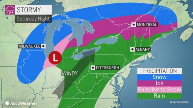
MONTREAL -- Road conditions promise to be perilous this weekend in Quebec, with the arrival of a low-pressure system from the south of the United States which will leave in its wake significant amounts of freezing rain, sleet and snow.
Getting around was already difficult on Saturday morning in the Quebec City region, where the Sûreté du Québec (SQ) observed more than a dozen accidents in less than two hours, around 8 a.m., on major highways. Fortunately, there was only property damage and some minor injuries, according to SQ Sgt. Audrey-Anne Bilodeau.
"If trips are not necessary and road or weather conditions are difficult, we are asking motorists to perhaps postpone these trips or outright cancel them," said the spokeswoman for the police force.
On its website, Environment and Climate Change Canada announced rain for the Quebec region in the morning, which would give way to heavy snow, sometimes accompanied by sleet, during the evening and night.
Total accumulations will exceed 25 centimetres, according to forecasts, and strong winds near the river will cause blowing snow, reducing visibility on the roads.
A cocktail on the horizon
Environment Canada meteorologist Simon Legault explained that this low-pressure system will first manifest itself by warmer weather.
"It's a big depression coming from the south of the United States, from the Texas region, which will pump a lot of heat and humidity from the Gulf of Mexico," said Legault.
This is why the precipitation will first appear as rain in southern Quebec, with up to 30 millimetres expected in places, especially in Estrie. Later in the day, the precipitation should change to freezing rain, sleet or snow, depending on the sector.
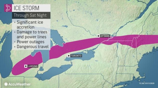
"All of southern Quebec will be affected until Sunday morning. In the south, there is freezing rain and, the more you go north, you have mixed precipitation," said the meteorologist. "There is a little more abundant snow expected in Quebec, Charlevoix, and La Tuque for example, even in the Bas-Saint-Laurent."
Hazardous roads
Teams from the Ministry of Transport (MTQ) were already mobilized on Saturday to deal with the storm.
Power outages could add to poor road conditions.
"The winds will rise in the St. Lawrence Valley, with gusts of 60 to 70 KM/H. The weight of the ice on the branches with the winds is still a situation conducive to power outages," warned Legault.
Hydro-Quebec's website indicated that a hundred teams are ready to intervene and that the number of workers deployed will "adjust according to the extent of the outages and the precise location where they will occur."
"The regions most at risk of being affected are Greater Montreal, the Laurentians, the Outaouais and the Montérégie. Vegetation could be damaged and fall on our network," the site reads.
In Sherbrooke, where the amount of freezing rain could be greater, the municipal civil security organization (OMSC) was already on the alert Friday and recommended to its population to have a 72-hour emergency kit on hand in order to be in able to cope with possible power outages.


