New online map tracks Montreal's potholes — and whether they've been fixed
Montreal might not have made the top 10 list of the worst roads in Quebec this year, but talk to any resident and they'll tell you that they're used to dodging craters and other crevasses big and small while navigating the city's streets.
Now, there is a new online tool to help track them in real-time.
The Montreal Pothole Reporting Tool not only tells you where the potholes are, it also lets you know once they've been fixed using crowdsourced reports and photos from people on the street.
The tool is the brainchild of Spatial Media, the same company behind an interactive map that showed the environmental impact of the trucker convoy demonstration in Ottawa last February.
Aaron Bernard, the company's creative and managing director for North America, said the Montreal pothole project is geared mostly toward cyclists, even though potholes annoy drivers and bike users alike.
"If I'm going to be cycling across the city, I can open this up and I can see how many potholes will be in my way along my journey," Bernard said in an interview.
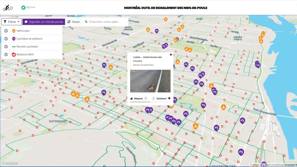 Purple and orange markers flag where a pothole has been reported by a member of the public. (Photo courtesy Spatial Media)
The Montreal Pothole Reporting Tool is not the only way people can report potholes in the city. The City of Montreal has a webpage dedicated to user-generated reports that include a description and location of the road flaw.
There's also an Instagram account, @potholesmtl, that uploads photos of Montreal craters from members of the public, along with a tongue-in-cheek description.
What is unique about Spatial Media's tool is that the map is interactive and people can mark potholes as "fixed" or "still there."
The map is dotted with purple markers flagging potholes affecting (and uploaded by) cyclists and pedestrians, while orange cones — a Montreal favourite — tag holes reported by people travelling in vehicles.
"Sometimes you're in traffic and see the same ones over and over every single day and I think people just get frustrated," Bernard said. "With the cyclist community specifically, it is kind of tight-knit. They do rides and nighttime rides and things like that and it would really be helpful for people to be able to — especially at night when you can't even see the potholes — to be able to launch the [website] and see what's going on."
It's no secret that Quebec roads are notorious for being poorly built and maintained, with some having the look and feel of a slice of aged Swiss cheese.
There's even a study that backs up that claim.
The Canadian Automobile Association (CAA) crowned Quebec as the province with the worst roads in Canada following a study released last year.
It found that Quebecers are paying upwards of $1.4 billion each year for poor roads and that the average driver spends about $258 annually to maintain their vehicle — more than double the Canadian average.
Last December, a strip of road in Montreal leading to Highway 20 West left two drivers stranded with blown tires on the same day.
It's one of the reasons why Montreal was chosen as the first city for the pothole project, Bernard said, adding several members of his team live in the city.
"They said, you know, when we cycle across town, it's like cycling on the moon," he said.
Bernard noted the long-term goal is to track the number of potholes by neighbourhood and how many the city is able to repair by the end of the season.
If it's successful, the map could launch in other Canadian cities.
Shopping Trends
The Shopping Trends team is independent of the journalists at CTV News. We may earn a commission when you use our links to shop. Read about us.


CTVNews.ca Top Stories

N.S. Progressive Conservatives win second majority government; NDP to form opposition
For the second time in a row, Tim Houston's Progressive Conservatives have won a majority government in Nova Scotia. But this time, the NDP will form the official opposition.
Paul Bernardo denied parole after victims' families plead he be kept behind bars
Notorious killer and rapist Paul Bernardo has been denied parole for a third time after the families of his victims made an emotional plea to the Parole Board of Canada on Tuesday to keep him behind bars.
'We would likely go out of business': Canadian business owners sound the alarm over Trump's tariffs
Business leaders across Canada are voicing concerns and fear over the widespread impact increased tariffs could have on their companies and workers, with some already looking to boost sales in other markets in the event their products become too expensive to sell to American customers.
Israel-Hezbollah ceasefire takes effect
A ceasefire between Israel and Iran-backed group Hezbollah took effect on Wednesday after U.S. President Joe Biden said both sides accepted an agreement brokered by the United States and France.
Longtime member of Edmonton theatre community dies during 'A Christmas Carol' performance
Edmonton's theatre community is in mourning after an actor died during a performance of "A Christmas Carol" at the Citadel Theatre on Sunday.
'We need to address those issues': Alberta Premier Danielle Smith won't denounce Trump tariff threat
Alberta Premier Danielle Smith says Canada should address U.S. president-elect Donald Trump's border concerns in the next two months, before he's back in the White House, instead of comparing our situation to Mexico's and arguing the tariff threats are unjustified.
Loonie tanks after Trump threatens tariffs on Canadian goods
The Canadian dollar fell to its lowest level since May 2020 after Donald Trump threatened to impose tariffs on Canadian goods shipped to the United States once he takes office in January.
Should Canada retaliate if Trump makes good on 25 per cent tariff threat?
After U.S. president-elect Donald Trump threatened to impose a 25 per cent tariff on all Canadian imports on his first day back in the White House unless his border concerns are addressed, there is mixed reaction on whether Canada should retaliate.
'We need to do better': Canadian leaders respond to Trump's border concerns
As U.S. president-elect Donald Trump threatens Canada with major tariffs, sounding alarms over the number of people and drugs illegally crossing into America, Conservative Leader Pierre Poilievre and some premiers say they agree that more could be done.
Toronto
-

Ford says Trump's proposed 25 per cent tariff on Canadian goods like 'a family member stabbing you right in the heart'
Ontario Premier Doug Ford says a 25 per cent tariff on all Canadian goods proposed by U.S. president-elect Donald Trump is akin to 'a family member stabbing you right in the heart.'
-
Serial killer Paul Bernardo denied parole for a third time: Key moments from today's hearing
Notorious killer Paul Bernardo has been denied parole for a third time following a hearing before the Parole Board of Canada.
-
Wanted suspect shot at passing vehicles on Highway 401 in Mississauga: OPP
Ontario Provincial Police are looking for a man who they say shot at several vehicles on Highway 401 in Mississauga Tuesday morning.
Ottawa
-

O-Train Line 2 and 4 opening pushed into December at the earliest
The head of Ottawa's transit service says we will learn more about the launch of O-Train Line 2 and 4 next week, as the north-south light rail line remains closed to passengers.
-
'It's insulting:' Ontario premier slams Trump on Canadian tariff threat
Ontario Premier Doug Ford is reacting to a threat from incoming U.S. president-elect Donald Trump to impose tariffs on imports from Canada, calling the proposal ‘insulting’ and emphasizing the need for leaders to work together on a response.
-
Questions regarding photo radar tickets in Ottawa amid postal workers' strike
As the ongoing Canada Post workers' strike continues to shut down mail delivery, there are questions about those photo radar tickets issued on Ottawa streets and what it means for speeders.
Atlantic
-
N.S. Progressive Conservatives win second majority government; NDP to form opposition
For the second time in a row, Tim Houston's Progressive Conservatives have won a majority government in Nova Scotia. But this time, the NDP will form the official opposition.
-
N.S. NDP leader says they are the alternative after official opposition win
Claudia Chender wasn’t able to bring the Nova Scotia NDP fully back to power on Tuesday night, but her electoral victories restored the party to its strongest position in a decade and made provincial history in the process.
-
N.S. Liberals lose official opposition status amid several electoral defeats
The Nova Scotia Liberals lost official opposition status on Tuesday night.
N.L.
-

'Who profits on hunger?': Inuit send pleading emails to minister about food costs
People in Nunavut and northern Labrador have been writing to Canadian government officials this year to say grocers were charging exorbitant prices despite receiving a federal subsidy.
-
As N.L. firm pivots, scientists say Canada's green hydrogen dreams are far-fetched
A Newfoundland energy company's embrace of data centres is raising doubts about eastern Canadian hopes of harnessing the region's howling winds to supply Germany with power from green hydrogen.
-
Canadian leads group pushing Vatican for zero-tolerance policy on abuse by clergy
An international group led by a Canadian is in Rome this week to push the Catholic Church to adopt a zero-tolerance policy on abuse by clergy.
Northern Ontario
-

Police seize $1M in drugs in northwestern Ont. bust
Suspects from Alberta and B.C. are in custody after Ontario Provincial Police made a massive drug bust at a rental unit near Kenora, Ont.
-
Sudbury resident scammed out of $20K, suspect from southern Ont. charged
A 21-year-old from southern Ontario has been charged with several offences after a victim from Greater Sudbury was tricked into giving him $20,000.
-
Loitering causing safety concerns by fire station in downtown Sudbury
There is enhanced security outside the main fire hall in downtown Sudbury in response to safety concerns.
London
-

Police look to identify 3 suspects in shooting investigation, arrest 4th suspect
London police are asking the public for help identifying suspects involved in a break, enter and shooting investigation.
-
Sarnia councillor won't apologize to mayor and staff for vulgar attacks during meeting
A controversial Sarnia councillor is under fire for a vulgar exchange during a city budget meeting on Tuesday.
-
The potential impact of Trump's tariff plans on St. Thomas EV factory
President-elect Donald Trump dropped a bombshell on Truth Social on Monday evening – stating “as one of my many first Executive Orders, I will sign all necessary documents to charge Mexico and Canada a 25% Tariff.”
Kitchener
-

Guelph man pleads guilty to leaving scene of crash that killed cyclist
A Guelph man has pleaded guilty to leaving the scene of a crash that resulted in the death of a cyclist and community advocate.
-
NHLer and former Kitchener Rangers staff member race to game on foot
Snow couldn't stop a Minnesota Wild hockey player from making it to his NHL debut, thanks to a little help from a former staff member of the Kitchener Rangers.
-
Paul Bernardo denied parole after victims' families plead he be kept behind bars
Notorious killer and rapist Paul Bernardo has been denied parole for a third time after the families of his victims made an emotional plea to the Parole Board of Canada on Tuesday to keep him behind bars.
Windsor
-

Downtown Mission concerned over ongoing Canada Post strike and donations tied up in negotiations
Officials at The Downtown Mission in Windsor are growing concerned about the amount of donations coming in since the strike at Canada Post began earlier this month.
-
Two suspects wanted for pharmacy break-in
Windsor police are searching for two suspects after a break-in at a pharmacy on Tecumseh Road East.
-
Lakeshore man facing more sex assault charges after second alleged victim comes forward
Essex County OPP say a Lakeshore man is facing more sexual assault charges after a second alleged victim has come forward.
Barrie
-

One person seriously injured in collision with dump truck
Emergency crews attended the scene of a serious collision between a dump truck and a minivan in Clearview Township.
-
OPP investigating assault on municipal law enforcement officer
Provincial police are investigating after a municipal law enforcement officer was allegedly assaulted by a group of individuals.
-
Local businesses brace for Trump's tariff threats
A threat of tariffs from U.S. President-elect Donald Trump has Canadians who do business south of border now keeping a close eye on his next moves.
Vancouver
-

'It's intimidation': Vancouver councillors told to stop displaying children's artwork during meeting
Two Vancouver city councillors were told to remove children's artwork from their desks during Tuesday's meeting, after one of their colleagues called the display of the drawings "intimidating."
-
Vancouver school trustees feud over public access at meetings
There were tense scenes at a Vancouver School Board meeting Monday night – with two trustees claiming there is a culture of secrecy.
-
Premiers plan meeting with PM, scramble to respond to Trump's tariff threats
Donald Trump's threat to slap 25 per cent tariffs on all Canadian goods imported into the United States has created major waves.
Vancouver Island
-

Public help sought in search for missing man with dementia
The family of a 64-year-old man with dementia is pleading with the public to help, urging a close look at pictures of their loved one – as a search for him extends into its fourth day.
-
BC Ferries changing direction on how it receives community feedback
BC Ferries says it’s changing route on how it receives feedback from the public.
-
B.C. court levies $4K fine, year-long ban for illegal fishing
A British Columbia man was handed a $4,000 fine and a one-year fishing ban after he was caught using a gillnet to illegally catch salmon.
Winnipeg
-

Premier Kinew says Trump's tariffs would cause a recession in Manitoba
Tariffs on Canadian goods headed to the United States would mean a recession in Manitoba. That is how Manitoba Premier Wab Kinew feels about comments from president-elect Donald Trump Monday.
-
Winnipeg exploring shatterproof glass for bus shelters as city struggles with repairs
As Winnipeg struggles to keep up with repairs to bus shelters with broken glass, the city is looking to test shatterproof glass in hopes that will save time and money down the road.
-
Walking for love: 100-year-old Winnipeg man continues to make trek to visit his wife
It's considered lucky to live to be 100, but often when you hit that milestone, you're faced with significant mobility issues. Not Winnipeg's Jack Mudry. The centenarian regularly walks five blocks to get where he wants to go, the care home where his wife Stella lives.
Calgary
-

Richard Pootmans stepping down from Calgary city council effective immediately
Calgary's Ward 6 Councillor Richard Pootmans is stepping down from city council, effective immediately.
-
TSB orders more training following incident involving plane in Calgary
The Transportation Safety Board says an incident that involved a Westjet plane hitting the runway in Calgary earlier this year was connected to an issue with pilot training on a particular model of aircraft.
-
Alberta takes aim at emissions cap, proposes rules on trespass and data gathering
Alberta Premier Danielle Smith says her government is eyeing a number of steps to challenge the proposed federal greenhouse gas emissions cap.
Edmonton
-

RCMP investigate death of MMA fighter in bout on Alberta First Nation
Police are investigating the death of a man at a mixed-martial arts fight Saturday on the Enoch First Nation adjacent to Edmonton.
-
Alberta takes aim at emissions cap, proposes rules on trespass and data gathering
Alberta Premier Danielle Smith says her government is eyeing a number of steps to challenge the proposed federal greenhouse gas emissions cap.
-
Fans, charity score in photo-op with Santa Claus and Oilers star at West Edmonton Mall
One Edmonton Oilers star was ho-ho-holding off on playing hockey Tuesday night at the city's biggest mall to help out with photos for charity.
Regina
-

Charged dropped against ex Regina high school teacher accused of sexual exploitation of student
A former Regina high school teacher accused of having a sexual relationship with a 15-year-old female student was acquitted on Tuesday of all five charges he faced, Regina’s Court of King’s Bench confirmed to CTV News.
-
Affordability and tariffs dominate talk as legislature resumes in Saskatchewan
Day two of an exceptionally short fall sitting of the Saskatchewan legislature has now wrapped. An opposition motion to cut the provincial gas tax was struck down while the government faced criticism on more than half a dozen portfolios.
-
SJHL game postponed in Weyburn over ammonia leak
A hockey game scheduled between the Yorkton Terriers and Weyburn Red Wings has been postponed due to a "mechanical issue."
Saskatoon
-

Saskatoon man hospitalized after he was allegedly stabbed in the forehead
A man has been taken to hospital after he was allegedly stabbed in the forehead early on Tuesday.
-
The Riche stuff: Off-season addition enjoying early success with Saskatoon Blades
The Saskatoon Blades were back in action Tuesday after a rare day off due to the snow Monday.
-
Affordability and tariffs dominate talk as legislature resumes in Saskatchewan
Day two of an exceptionally short fall sitting of the Saskatchewan legislature has now wrapped. An opposition motion to cut the provincial gas tax was struck down while the government faced criticism on more than half a dozen portfolios.