Was that a tornado? Basic guide to identificaiton
On Wednesday night, Environment and Climate Change Canada and the Northern Tornadoes Project (NTP) at Western University confirmed that Ontario and Quebec were hit by at least four tornadoes.
NTP Executive Director David Sills explained that this week's tornadoes were quickly confirmed because teams had video evidence clearly showing a tornado causing damage.
"Last night, there was evidence both in Ontario and Quebec of a tornado based on video," he said. "It was backed up by radar, and also people on the ground reporting damage. So we didn't have too much of a problem confirming tornadoes in Ontario, Quebec last evening."
Violently rotating column of air
To be classified as a tornado, the funnel cloud must be travelling at least 90 km/h, which shows evidence that it could produce damage.
"Basically, it's a rotating column of air that's connected to the cloud base and connected to the ground, and has damaging winds associated with it," said Sills.
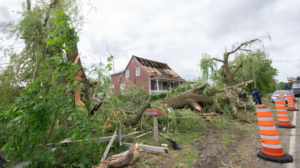 Storm damage is seen in Tres-Saint-Redempteur, Quebec on Tuesday, May 28, 2024 after a suspected tornado went through yesterday evening. (Ryan Remiorz/The Canadian Press)
Environment Canada uses the Enhanced Fujita (EF) scale, which goes from EF rating 1 (90-130 km/h) to 5 (315 km/h or more).
"The EF-scale employs a large number of damage indicators, ranging from residential housing to office towers to trees," Environment Canada says. "Wind speeds are more accurately related to wind damage thanks to an expert elicitation process that involved the meteorological, engineering and architecture communities."
Tornado or a downburst
Sills said the first thing teams need to do is make sure the phenomenon is not something else.
"A lot of times, when we get reports of damage, the first thing we need to do is determine if it was a tornado or a downburst that caused the wind damage," he said. "The patterns that are produced by those two different phenomena are quite different."
In a tornado, the wind is coming in towards the bottom of the storm and travelling up.
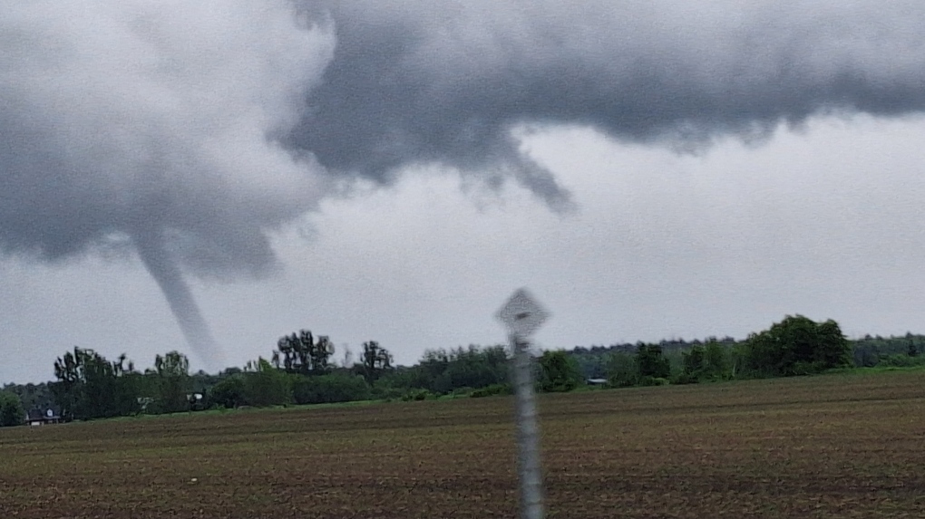 Multiple homes have been damaged as a tornado appears to have touched down in Rigaud, Que. (Baradaran Glady)
A downburst is the opposite: the wind starts at the top and spreads out when it hits the ground.
"You've got one pattern that's kind of a converging pattern, and usually you get a narrow, long path with a tornado, whereas with a downburst it's a diverging path, so all the trees or whatever are pushed out from a central point," he said.
The NTP says most showers and thunderstorms produce downbursts and that these can interfere with aircraft taking off or landing.
Shopping Trends
The Shopping Trends team is independent of the journalists at CTV News. We may earn a commission when you use our links to shop. Read about us.


CTVNews.ca Top Stories

Trudeau's 2024: Did the PM become less popular this year?
Justin Trudeau’s numbers have been relatively steady this calendar year, but they've also been at their worst, according to tracking data from CTV News pollster Nik Nanos.
Calling all bloodhounds: These P.E.I. blood donors have four legs and a tail
Dogs are donating blood and saving the lives of canines at the University of Prince Edward Island's Atlantic Veterinary College in Charlottetown.
London Liberal MP's say that Trudeau is taking time to reflect on the future of the party
Both of London’s Liberal MP’s are choosing their words carefully when it comes to their party's leadership future. They were asked about the situation in Ottawa at Friday's housing announcement in London.
Wild boar hybrid identified near Fort Macleod, Alta.
Acting on information, an investigation by the Municipal District of Willow Creek's Agricultural Services Board (ASB) found a small population of wild boar hybrids being farmed near Fort Macleod.
Manhunt underway after woman, 23, allegedly kidnapped, found alive in river
A woman in her 20s who was possibly abducted by her ex is in hospital after the car she was in plunged into the Richelieu River.
New rules clarify when travellers are compensated for flight disruptions
The federal government is proposing new rules surrounding airlines' obligations to travellers whose flights are disrupted, even when delays or cancellations are caused by an "exceptional circumstance" outside of carriers' control.
Summer McIntosh makes guest appearance in 'The Nutcracker'
Summer McIntosh made a splash during her guest appearance in The National Ballet of Canada’s production of 'The Nutcracker.'
A 9-year-old is among 5 killed in the Christmas market attack in Germany
A nine-year-old was among five people killed when a Saudi doctor intentionally drove into a Christmas market teeming with holiday shoppers in the German city of Magdeburg, an official said Saturday.
Toronto firefighters rescue man who fell into sinkhole in Yorkville
A man who fell into a sinkhole in Yorkville on a snowy Friday night in Toronto has been rescued after being stuck in the ground for roughly half an hour.
Toronto
-

Homicide investigation underway in Toronto's Corso Italia neighbourhood
A homicide investigation is underway after a male who was found in Toronto’s Corso Italia neighbourhood early Saturday morning died in hospital, police say.
-
Toronto firefighters rescue man who fell into sinkhole in Yorkville
A man who fell into a sinkhole in Yorkville on a snowy Friday night in Toronto has been rescued after being stuck in the ground for roughly half an hour.
-
Winning $20-million Lotto Max ticket sold in Hamilton
Someone who purchased a Lotto Max ticket in Hamilton for Friday night’s draw is now $20-million richer.
Ottawa
-

OPP nab 18 impaired drivers during the fourth week of the RIDE campaign
Eighteen more drivers have been added to Santa's blacklist during the fourth week of the Festive RIDE campaign (Reduce Impaired Driving Everywhere) in eastern Ontario, according to the Ontario Provincial police.
-
Here’s how to master the art of giving this holiday
Navigating the world of giving back to the people who made your life easy throughout the year can be tricky, especially with the rising cost of living, but there are ways to do it with grace, according to an etiquette expert.
-
What's happening in Ottawa over the Christmas holidays
CTVNewsOttawa.ca looks at things to do in Ottawa over the holiday season.
Atlantic
-

Cancellations, closures accompany Maritime storm
There are a number of closures in the Maritimes Saturday after a nor'easter brought heavy snow to parts of the region.
-
Calling all bloodhounds: These P.E.I. blood donors have four legs and a tail
Dogs are donating blood and saving the lives of canines at the University of Prince Edward Island's Atlantic Veterinary College in Charlottetown.
-
Maritime weather: Warnings expanded as nor'easter approaches
Snowfall warnings are now in effect for mainland Nova Scotia and southeastern New Brunswick.
N.L.
-

Newfoundland woman washed sick patients' hair every Saturday for more than 20 years
A retired nurse and teacher in Newfoundland was honoured this week for her volunteer work, which included more than two decades washing the hair of bedridden hospital patients.
-
Newfoundland man facing more charges related to youth sex crimes
A 64-year-old Newfoundland man charged with dozens of sex crimes involving young people is facing several new charges.
-
After fanfare of Churchill Falls deal, Newfoundland urged to learn its dam lessons
Energy observers in Newfoundland and Labrador are urging the provincial government to take a sober second look at a massive tentative deal announced last week with Quebec that promises to deliver hundreds of billions of dollars in revenue to the Atlantic province.
Northern Ontario
-

Robinson Superior First Nations provided settlement offer from Canada over annuities owed
Details haven’t been made public yet about the settlement offer presented on Friday by Canada to the 12 First Nations in the Robinson Superior Treaty Territory.
-
Northern Ont. man illegally killed three moose, one deer
A man from the northwestern Ontario community of Dinorwic has been found guilty of multiple hunting offences and fined $6,500, banned from hunting for five years and placed on probation for 18 months.
-
Poilievre writes to GG calling for House recall, confidence vote after Singh declares he's ready to bring Liberals down
Conservative Leader Pierre Poilievre has written to Gov. Gen. Mary Simon, imploring her to 'use your authority to inform the prime minister that he must' recall the House of Commons so a non-confidence vote can be held. This move comes in light of NDP Leader Jagmeet Singh publishing a letter stating his caucus 'will vote to bring this government down' sometime in 2025.
London
-

London Liberal MP's say that Trudeau is taking time to reflect on the future of the party
Both of London’s Liberal MP’s are choosing their words carefully when it comes to their party's leadership future. They were asked about the situation in Ottawa at Friday's housing announcement in London.
-
Cold Weather Alert issued as temperatures could reach -18˚C or lower
With Environment Canada forecasting temperatures as low as -16˚C and -18˚C with the wind chill, Southwestern Public Health (SWPH) is issuing a cold weather alert for its region.
-
Lights out in Listowel, OPP investigate motor vehicle collision with hydro box
Perth OPP are on the scene of a collision on Saturday morning in which a vehicle struck a hydro box.
Kitchener
-

Hydro out in Listowel following collision
Police say a collision between a vehicle and hydro box happened Saturday morning and as a result, hydro is out in the town of Listowel.
-
Suspect sought in Paris, Ont. assault investigation
The Brant County Ontario Provincial Police responded to a reported assault on Scott Avenue in Paris just before 10 p.m. on Dec. 9.
-
Winning $20-million Lotto Max ticket sold in Hamilton
Someone who purchased a Lotto Max ticket in Hamilton for Friday night’s draw is now $20-million richer.
Windsor
-

'It's got to stop, it's that simple': Windsor cab drivers warn of unregulated operators
Drivers now compete with individuals using social media to advertise rides at cut-rate prices. One person offers $10 rides within the city, while another promotes daily trips from Windsor to Toronto for $45 per person.
-
Windsor-Essex toes the threshold of a cold warning, with temperatures set to plunge tonight
It’s going to be bitterly cold outside overnight on Saturday, although we will remain just under the threshold for an official cold warning from the health unit.
-
Saying farewell to the Phog Lounge's iconic red building
For more than a decade, Phog Lounge has been the backdrop for some of this city’s most creative poets, but with Phog planning a big move in 2025, the future of its poetry nights is taking a new turn.
Barrie
-

Multi-vehicle collision on Highway 11 in Oro-Medonte
Southbound traffic along Highway 11 through Oro-Medonte was brought to a crawl Friday after a multi-vehicle collision.
-
High school teacher charged with sexual assault amid allegations involving a student
A 51-year-old teacher from Georgina has been charged with sexual assault following allegations involving a student.
-
Driver charged after vehicle crashes into Barrie home
A driver was arrested Thursday night after a vehicle crashed into a home in Barrie.
Vancouver
-

B.C. woman with photographic memory strives to make unforgettable Christmas displays
Although Alisha Pauling is looking through old pictures, she doesn’t need them to remember her Christmases past. She has a photographic memory.
-
Internet stranger's kind gesture restores Canucks fan's faith in humanity
A Nanaimo, B.C., couple is in awe at the kindness of an internet stranger who helped them track down a coveted Christmas gift.
-
16-year-old German exchange student dies after North Vancouver crash
A 16-year-old high school student from Germany who was hit by a Jeep in North Vancouver, B.C., last weekend has died in hospital, authorities confirmed.
Vancouver Island
-

B.C. man 'trying to appear cool' with loaded handgun at nightclub sentenced
A 23-year-old British Columbia man who pleaded guilty to carrying a loaded handgun inside a crowded nightclub has been sentenced to two-and-a-half years in prison.
-
Warrants issued for 'violent offenders' after Nanaimo jewelry store robbery
Authorities are asking for the public 's help finding two suspects wanted in connection with a Nanaimo, B.C., jewelry store robbery earlier this year.
-
B.C. teachers cultivate community through merry music videos
Although his classroom is filled with students now, Jeff Bordal will never forget how empty it once was.
Winnipeg
-

Residential parking ban lifted in Winnipeg
The City of Winnipeg has lifted its parking ban on residential streets.
-
Bail denied for Winnipeg woman accused of killing animals in online videos
Warning: This story contains disturbing details. Discretion is advised. A Winnipeg woman accused of making videos of animals being tortured and killed that were sold on the dark web was denied bail.
-
Ace Burpee's Top 100 Most Fascinating Manitobans of 2024
It’s been another year of Manitobans doing interesting, incredible and cool things. The hardest part of compiling this list is cutting it off at 100.
Calgary
-

Wild boar hybrid identified near Fort Macleod, Alta.
Acting on information, an investigation by the Municipal District of Willow Creek's Agricultural Services Board (ASB) found a small population of wild boar hybrids being farmed near Fort Macleod.
-
1 man hospitalized in serious condition after Friday collision in northeast
A man is in hospital after being struck by a truckin northeast Calgary on Friday afternoon.
-
Here’s why your Calgary Enmax bill may go down in 2025
The City of Calgary had some good news for Calgary residents Friday morning, announcing that their Enmax bill may get a bit lower in 2025.
Edmonton
-
Second inmate dies at Edmonton Remand Centre in as many days
An inmate died at the Edmonton Remand Centre on Thursday night.
-
It's eggnog season. The boozy beverage dates back to medieval England but remains a holiday hit
At Scoma's Restaurant in San Francisco, this holiday season 's batch of eggnog began 11 months ago.
-
Child pornography charges laid against 52-year-old woman
A Sherwood Park woman has been charged with two child pornography offences.
Regina
-

'A sense of holiday spirit': Local shelter hosts Regina’s most vulnerable at annual Christmas dinner
For nearly 35 years, Souls Harbour Rescue Mission has been serving an annual Christmas dinner to Regina’s most vulnerable.
-
Drivers encouraged to check Highway Hotline before holiday travel
After receiving another big dump of snow over the past couple of days, Saskatchewan drivers have had to contend with some treacherous driving conditions.
-
Regina man creates snow sculpture to spread joy and inspire donations
A Regina man created a snow sculpture of a Santa head to spread joy and inspire donations to Big Brothers Big Sisters.
Saskatoon
-

Sask. lawyers defend judge for staying fatal THC-impaired driving charge
The Saskatchewan Trial Lawyers Association is defending a provincial court judge, who’s facing backlash for staying a charge in a high-profile case involving the death of a child.
-
Prince Albert woman collects donations to make Christmas hampers for community
A Prince Albert woman is spreading holiday cheer by organizing Christmas hampers for those in need.
-
Saskatoon police release details about latest homicide
Saskatoon police are releasing new details about the city’s latest homicide, although no charges have yet been laid.