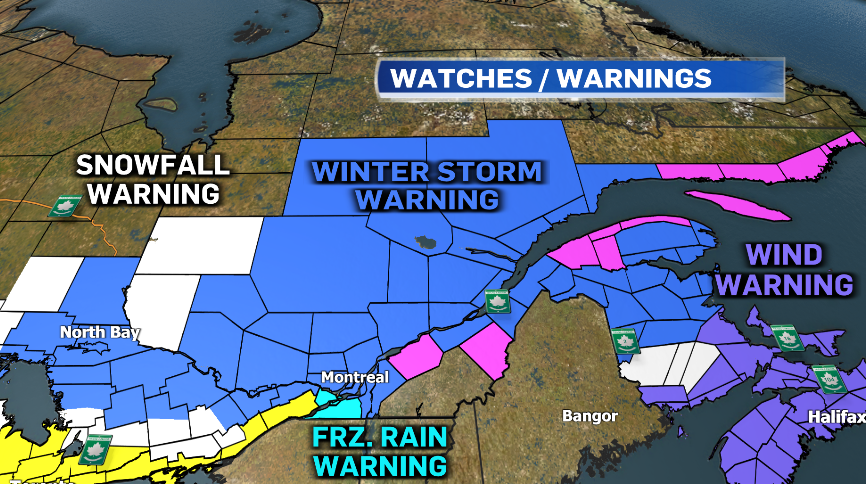
Snow hits Quebec on Tuesday; ice and rain to come
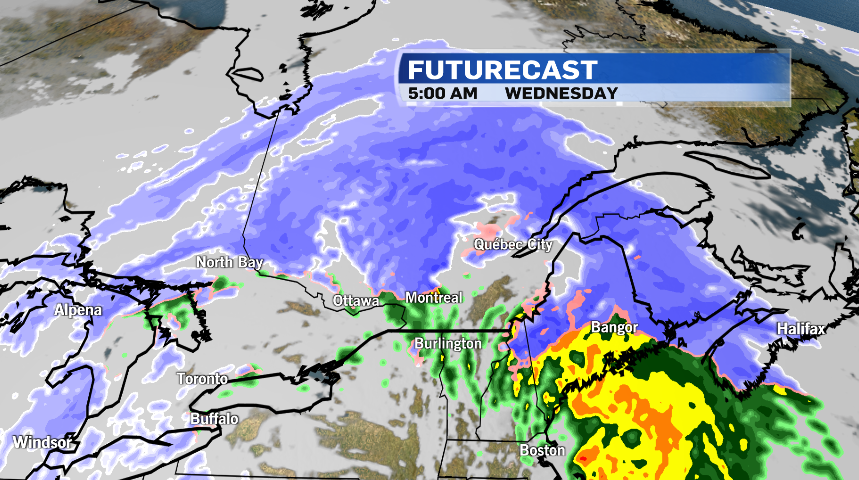
A Texas low is moving across eastern Canada, bringing a combination of heavy snow, freezing rain and strong winds.
Close to 15 centimetres of snow are expected to hit Montreal Tuesday, and widespread winter storm warnings have been issued by Environment and Climate Change Canada.
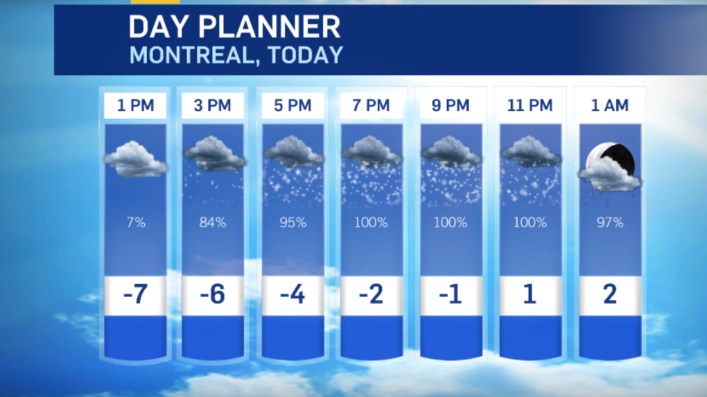
Montreal saw steady snow beginning early Tuesday evening before it's expected to change over to freezing rain later in the evening.
The heaviest snow should fall north of the city.
The Laurentians could see up to 35 cm of snow, while Quebec City may see up to 40 cm of accumulation.
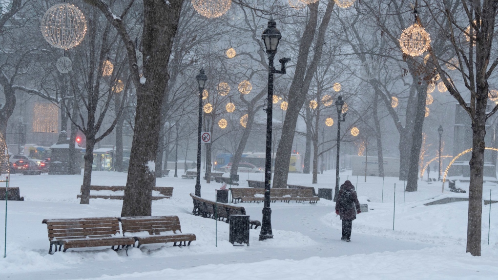 People walk in downtown Montreal, Tuesday, Jan. 9, 2024. THE CANADIAN PRESS/Christinne Muschi
The Eastern Townships should see between five and 10 cm of snow Tuesday night with freezing rain and ice pellets mixed in.
Freezing rain warnings are also in effect southwest of Montreal, with 10 cm of snow and ice pellets expected.
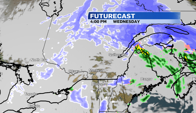
Montreal could also expect northeasterly winds with gusts up to 70 km/h Tuesday night before shifting to the southwest early Wednesday morning. That may cause temperatures to rise above the freezing mark.
Rain is expected for the Wednesday morning commute, with Montreal seeing between 10 and 20 mm.
The messy mix of precipitation could cause difficult travel conditions.
"Rapidly accumulating snow could make travel difficult over some locations," Environment and Climate Change Canada notes. "Surfaces such as highways, roads, walkways and parking lots may become icy and slippery."
Officials warn there may be a significant impact on rush hour traffic in urban areas.
"Consider postponing non-essential travel until conditions improve," the weather agency stresses.
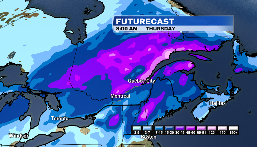
Dryer weather is expected on Wednesday afternoon.
Colder air should wrap in behind the system for Thursday and Friday, but another snowstorm is expected Friday night into Saturday, with 15 to 20 cm possible.

Shopping Trends
The Shopping Trends team is independent of the journalists at CTV News. We may earn a commission when you use our links to shop. Read about us.


CTVNews.ca Top Stories

Can the Governor General do what Pierre Poilievre is asking? This expert says no
A historically difficult week for Prime Minister Justin Trudeau and his Liberal government ended with a renewed push from Conservative Leader Pierre Poilievre to topple this government – this time in the form a letter to the Governor General.
'I'm still thinking pinch me': lost puppy reunited with family after five years
After almost five years of searching and never giving up hope, the Tuffin family received the best Christmas gift they could have hoped for: being reunited with their long-lost puppy.
Two U.S. Navy pilots shot down over Red Sea in apparent 'friendly fire' incident, U.S. military says
Two U.S. Navy pilots were shot down Sunday over the Red Sea in an apparent 'friendly fire' incident, the U.S military said, marking the most serious incident to threaten troops in over a year of America targeting Yemen's Houthi rebels.
Big splash: Halifax mermaid waves goodbye after 16 years
Halifax's Raina the Mermaid is closing her business after 16 years in the Maritimes.
OPP find wanted man by chance in eastern Ontario home, seize $50K worth of drugs
A wanted eastern Ontario man was found with $50,000 worth of drugs and cash on him in a home in Bancroft, Ont. on Friday morning, according to the Ontario Provincial Police (OPP).
Bluesky finds with growth comes growing pains - and bots
Bluesky has seen its user base soar since the U.S. presidential election, boosted by people seeking refuge from Elon Musk's X, which they view as increasingly leaning too far to the right given its owner's support of U.S. president-elect Donald Trump, or wanting an alternative to Meta's Threads and its algorithms.
B.C. mayor gets calls from across Canada about 'crazy' plan to recruit doctors
A British Columbia community's "out-of-the-box" plan to ease its family doctor shortage by hiring physicians as city employees is sparking interest from across Canada, says Colwood Mayor Doug Kobayashi.
It was Grandma, in the cafe with a Scrabble tile: Game cafes are big holiday business
It’s the holidays, which means for many across the Prairies, there’s no better time to get locked in a dungeon with a dragon.
Cancer centre raises $2.7 million for purchase of 'game changer' surgical robot
The Windsor Cancer Centre Foundation has raised a record breaking $2.7 million through the Grow on Windsor Campaign.
Toronto
-

Cold in Toronto feels like -21 with the wind chill Sunday morning
The cold weather hanging over Toronto isn’t letting up, and it currently feels like -21 with the wind chill.
-
Toronto police investigating 2 separate east-end shootings, no injuries reported
Toronto police are investigating two separate east-end shootings that occurred within 12 hours of each other.
-
Three-vehicle crash leaves 4 people injured in Brampton
Four people were injured in a three-car crash in Brampton early Sunday morning.
Ottawa
-
 BREAKING NEWS
BREAKING NEWS 4 children, 4 adults taken to hospital following ‘potential Carbon Monoxide’ call in Vanier
The Ottawa Paramedic Service says eight people were taken to hospital in serious condition after a "potential Carbon Monoxide" call Sunday morning in the neighbourhood of Vanier.
-
Flooding started, ice still thin: Here’s the latest update about the Rideau Canal Skateway
Preparations to open the Rideau Canal Skateway are underway, as deep freeze continues to linger around Ottawa this weekend.
-
OPP find wanted man by chance in eastern Ontario home, seize $50K worth of drugs
A wanted eastern Ontario man was found with $50,000 worth of drugs and cash on him in a home in Bancroft, Ont. on Friday morning, according to the Ontario Provincial Police (OPP).
Atlantic
-

'On death row.' Wrongfully convicted N.B. man has mixed feelings since exoneration
Robert Mailman, 76, was exonerated on Jan. 4 of a 1983 murder for which he and his friend Walter Gillespie served lengthy prison terms.
-
Cape Breton police arrest second person in missing man investigation
A second person has been arrested in the disappearance of Justin MacDonald in Cape Breton.
-
Icy conditions persist, parking ban lifted in Halifax
Halifax has lifted a parking ban for Zone 1 – Central and Zone 2- Non-Central that was enforced Friday and Saturday night to accommodate snow removal following a winter storm.
N.L.
-

Newfoundland woman washed sick patients' hair every Saturday for more than 20 years
A retired nurse and teacher in Newfoundland was honoured this week for her volunteer work, which included more than two decades washing the hair of bedridden hospital patients.
-
Newfoundland man facing more charges related to youth sex crimes
A 64-year-old Newfoundland man charged with dozens of sex crimes involving young people is facing several new charges.
-
After fanfare of Churchill Falls deal, Newfoundland urged to learn its dam lessons
Energy observers in Newfoundland and Labrador are urging the provincial government to take a sober second look at a massive tentative deal announced last week with Quebec that promises to deliver hundreds of billions of dollars in revenue to the Atlantic province.
Northern Ontario
-

Robinson Superior First Nations provided settlement offer from Canada over annuities owed
Details haven’t been made public yet about the settlement offer presented on Friday by Canada to the 12 First Nations in the Robinson Superior Treaty Territory.
-
Can the Governor General do what Pierre Poilievre is asking? This expert says no
A historically difficult week for Prime Minister Justin Trudeau and his Liberal government ended with a renewed push from Conservative Leader Pierre Poilievre to topple this government – this time in the form a letter to the Governor General.
-
Northern Ont. man illegally killed three moose, one deer
A man from the northwestern Ontario community of Dinorwic has been found guilty of multiple hunting offences and fined $6,500, banned from hunting for five years and placed on probation for 18 months.
London
-

Dreaming of a white Christmas?
Christmas is right around the corner, and while winter has been touch and go, there’s a good chance that we will not be looking out the window at a winter wonderland this week.
-
Owen Sound to invest half a million in community splashpad and playground
The half a million dollar investment will replace the existing 25 year old playground structure and renew the splashpad – which at 15 years old requires some servicing.
-
Warming up your car before you head out? Here's how to make sure you're not a target for auto theft.
With the bitter chill of the cold weather, it can be tempting to warm up your car before you head out – but London police has issued a warning to motorists that their warmup habits may have them left out in the cold.
Kitchener
-
Can the Governor General do what Pierre Poilievre is asking? This expert says no
A historically difficult week for Prime Minister Justin Trudeau and his Liberal government ended with a renewed push from Conservative Leader Pierre Poilievre to topple this government – this time in the form a letter to the Governor General.
-
'I'm still thinking pinch me': lost puppy reunited with family after five years
After almost five years of searching and never giving up hope, the Tuffin family received the best Christmas gift they could have hoped for: being reunited with their long-lost puppy.
-
Driver charged with 'several offences' after being stopped on Waterloo highway
A 24-year-old man has been charged after dangerously driving across two Waterloo Regional highways.
Windsor
-

Dreaming of a white Christmas?
Christmas is right around the corner, and while winter has been touch and go, there’s a good chance that we will not be looking out the window at a winter wonderland this week.
-
Cancer centre raises $2.7 million for purchase of 'game changer' surgical robot
The Windsor Cancer Centre Foundation has raised a record breaking $2.7 million through the Grow on Windsor Campaign.
-
Feeling punny? Why not submit your idea for Tecumseh's snowploughs!
Whether you want to make a joke, honour the snowy season, or name a snow plough in honour of a local landmark, you can submit your ideas right now.
Barrie
-

One driver faces several charges following Highway 400 crash in Oro-Medonte
Traffic came to a standstill Friday afternoon following a single-vehicle collision on Highway 400 in Oro-Medonte.
-
High school teacher charged with sexual assault amid allegations involving a student
A 51-year-old teacher from Georgina has been charged with sexual assault following allegations involving a student.
-
Hospice Simcoe mourns loss of COPE service pup, after 7.5 years of service
The Hospice Simcoe community is mourning the loss of their Canine Opportunity, People Empowerment (COPE) service dog, Daisy.
Vancouver
-

Man wounded in Mission, B.C., shooting
One man was injured in a shooting in the Lower Mainland city of Mission Saturday morning, Mounties confirmed.
-
Winds exceeding 120 km/h reported in parts of B.C. coast
Residents of parts of the British Columbia coast are again bracing for high winds, with gusts forecasted to reach 110 km/h in some areas.
-
2 dead after car crash in Burnaby
Two people were killed in a car crash in Burnaby early Saturday morning, police confirmed.
Vancouver Island
-

B.C. mayor gets calls from across Canada about 'crazy' plan to recruit doctors
A British Columbia community's "out-of-the-box" plan to ease its family doctor shortage by hiring physicians as city employees is sparking interest from across Canada, says Colwood Mayor Doug Kobayashi.
-
B.C. woman with photographic memory strives to make unforgettable Christmas displays
Although Alisha Pauling is looking through old pictures, she doesn’t need them to remember her Christmases past. She has a photographic memory.
-
Internet stranger's kind gesture restores Canucks fan's faith in humanity
A Nanaimo, B.C., couple is in awe at the kindness of an internet stranger who helped them track down a coveted Christmas gift.
Winnipeg
-

Muslim youth group distributes meals to Winnipeg's most vulnerable
In the spirit of giving season, a Muslim youth group made its way through the city’s downtown distributing meals to those in need.
-
'Good deals for Christmas': Turkey prices down from last year
With just days to go before Christmas, one of the big items for the big feast could be cheaper this year. Numbers from Agriculture and Agri-Food Canada show that during November this year, turkey prices were down from the same time last year.
-
Ace Burpee's Top 100 Most Fascinating Manitobans of 2024
It’s been another year of Manitobans doing interesting, incredible and cool things. The hardest part of compiling this list is cutting it off at 100.
Calgary
-
It was Grandma, in the cafe with a Scrabble tile: Game cafes are big holiday business
It’s the holidays, which means for many across the Prairies, there’s no better time to get locked in a dungeon with a dragon.
-
Traffic advisory issued by RCMP due to poor driving conditions south of Calgary and north of Red Deer
Alberta RCMP issued a traffic advisory early Sunday morning due to poor driving conditions throughout the province.
-
Flames get goals from 6 players in a 6-4 victory over the Blackhawks
Jonathan Huberdeau, Connor Zary, Blake Coleman, and Matt Coronato each had a goal and an assist as the Calgary Flames beat the Chicago Blackhawks 6-4 on Saturday.
Edmonton
-

'There’s no support': Domestic abuse survivor shares difficulties leaving her relationship
An Edmonton woman who tried to flee an abusive relationship ended up back where she started in part due to a lack of shelter space.
-
Oilers finding ways to thrive in close encounters
Leon Draisaitl scored 18 seconds into overtime to extend his point streak to eight games as the Edmonton Oilers overcame a slow start to win their second straight game in extra time, defeating the San Jose Sharks 3-2 on Saturday.
-
It was Grandma, in the cafe with a Scrabble tile: Game cafes are big holiday business
It’s the holidays, which means for many across the Prairies, there’s no better time to get locked in a dungeon with a dragon.
Regina
-

Gathering held in Regina to recognize Winter Solstice
Regina's mâmawêyatitân centre held a day of gathering for the Winter Solstice on Saturday.
-
Canada's first sustainable Tim Hortons location to open in Regina this weekend
Canada’s first sustainable Tim Hortons opens in Regina this weekend. The restaurant, located in the city’s east end, features design and operating features that minimize environmental impact.
-
Gravelbourg's transportation program celebrates addition of new vehicle and garage
The town of Gravelbourg is celebrating the addition of a new vehicle and garage which will be used in their local transportation program.
Saskatoon
-

Sask. police investigating mischief incident after bomb report in school
Prince Albert police are investigating a mischief incident after a bomb report in a school Friday afternoon.
-
Prince Albert woman collects donations to make Christmas hampers for community
A Prince Albert woman is spreading holiday cheer by organizing Christmas hampers for those in need.
-
Sask. lawyers defend judge for staying fatal THC-impaired driving charge
The Saskatchewan Trial Lawyers Association is defending a provincial court judge, who’s facing backlash for staying a charge in a high-profile case involving the death of a child.