Biggest snowfall of the month so far expected in Montreal
Montrealers should expect a slow commute Friday morning as a disturbance could bring snow to southwestern Quebec starting Thursday night.
After a sunny start to the day, clouds should begin to increase through the afternoon, with light snow expected to begin after the evening rush hour.
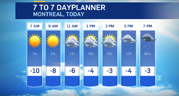
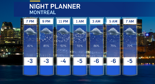
Snow is expected to be steady through the evening hours and continue into Friday morning, causing slick roads and sidewalks.
While the city is only expecting to see between five and seven centimetres of accumulation, it will be the biggest snowfall of the month so far, with February marked by dry, warm weather.
Montreal has only picked up a centimetre of snow so far this month. Normal snowfall for February is about 40 cm.
The last snowstorm in the city occurred over a month ago when Montreal picked up close to 17 cm on Jan. 13.
Environment and Climate Change Canada has issued travel advisories on the Ontario side of the border, warning of reduced visibility late Thursday afternoon and evening with five to 10 cm of accumulation and peak snowfall rates of two to four cm per hour.
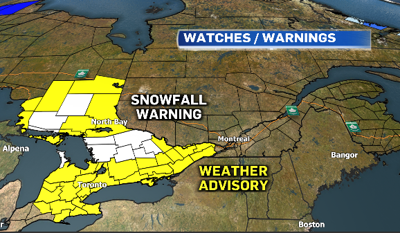
Snowfall warnings are also in effect for parts of Ontario, with up to 15 cm possible.
- READ MORE: Winter storm warnings for parts of Atlantic Canada: 60 cm of snow possible, some schools cancelled
Montreal will see a few scattered flurries through the weekend, with drier weather returning next week.
Daytime highs are expected to climb above the freezing mark by Wednesday.

Shopping Trends
The Shopping Trends team is independent of the journalists at CTV News. We may earn a commission when you use our links to shop. Read about us.


CTVNews.ca Top Stories

Calgary woman stranded in Mexico after husband's death during diving trip
A Calgary woman is struggling to return home after her husband died while diving in Mexico, leaving her stranded and facing financial hardship.
Liberal caucus chairs meeting to talk Trudeau today, PM attends Canada-U.S. cabinet committee
Prime Minister Justin Trudeau is back in Ottawa today, but with him yet to signal he's ready to address the snowballing resignation calls, the Liberal caucus' regional chairs have called a meeting today to discuss next steps.
Sea and Himalayan salts recalled in Canada: 'Do not use, serve or distribute'
Two brands of sea and Himalayan salt are being recalled in Canada due to pieces of plastic found in the products.
Judge sets Trump's sentencing in hush money case for Jan. 10, but signals no jail time
In an extraordinary turn, a judge Friday set U.S. president-elect Donald Trump's sentencing in his hush money case for Jan. 10, but indicated he wouldn't be jailed.
N.S. community shocked by deaths of father, daughter; suspect was wanted in Toronto shooting
A Nova Scotia community is mourning the loss of two of its members after they were shot and killed in Halifax on New Year’s Eve.
When do I receive federal benefits this year? Payment dates for 2025
From the Canada Child Benefit to Old Age Security, federal payment dates have been determined for 2025. Find out when you can expect your payments.
'Mystery volcano' that erupted and cooled Earth in 1831 has finally been identified
An unknown volcano erupted so explosively in 1831 that it cooled Earth's climate. Now, nearly 200 years later, scientists have identified the 'mystery volcano.'
Ontario aiming to send out $200 rebate cheques later this month or early February
Ontarians should receive their $200 rebate cheque from the province by the end of January or early February, a government spokesperson confirmed in an email Friday.
FORECAST
FORECAST Weather warnings issued for nearly all of Canada's provinces and territories
Nearly every province and territory in Canada is subject to weather advisories heading into the weekend.
Toronto
-

Union representing Ontario college faculty issues five-day strike notice
Ontario college students could soon see their winter semester cut short as the union representing faculty at the province’s 24 public colleges could walk off the job as early as Thursday next week.
-
Ontario aiming to send out $200 rebate cheques later this month or early February
Ontarians should receive their $200 rebate cheque from the province by the end of January or early February, a government spokesperson confirmed in an email Friday.
-
Sea and Himalayan salts recalled in Canada: 'Do not use, serve or distribute'
Two brands of sea and Himalayan salt are being recalled in Canada due to pieces of plastic found in the products.
Ottawa
-

Highrise fire on Ramsey Crescent displaces 39 residents
The Ottawa Paramedic Service says four adult women were taken to hospital following a fire that happened in a highrise on Ramsey Crescent, in the west end of Ottawa, in the early hours of Friday morning.
-
OTTAWA'S LRT
OTTAWA'S LRT All aboard Ottawa's new LRT line: What you need to know about the new north-south Line 2 and Line 4
Ottawa’s new north-south rail line will open to the public on Monday, Jan. 6, connecting downtown Ottawa and Riverside South with a spur to the Ottawa International Airport.
-
Canadian restaurant chain Philthy Philly's coming to Ottawa's ByWard Market
Philthy Philly's, a Canadian cheesesteak sandwich and poutine restaurant, is coming to Ottawa's ByWard Market this year.
Atlantic
-

N.S. community shocked by deaths of father, daughter; suspect was wanted in Toronto shooting
A Nova Scotia community is mourning the loss of two of its members after they were shot and killed in Halifax on New Year’s Eve.
-
Saint John man charged with second-degree murder in wife’s Christmas Eve death
A man accused of murdering his wife on Christmas Eve made his first court appearance in Saint John, N.B., Friday morning.
-
Haligonians raise a glass to Dry January
Dry January isn’t new but the tradition of taking a break from alcohol after the celebratory Christmas season is fueling changes in the food and beverage industry.
N.L.
-

Labradorians pay thousands to fly to Newfoundland. Could a Quebec energy deal help?
An airport executive in Labrador hopes a new energy deal with Quebec could help attract a competing airline company to the northern region, where flights costs have climbed at more than three times the national rate.
-
Icebreaker on hand in Labrador to guide season's last freight arrivals by ferry
A Canadian Coast Guard icebreaker is in central Labrador until Saturday to guide the Kamutik W ferry on its last freight deliveries of the season.
-
Whooping cough in Canada: Outbreaks or case increases reported in these provinces
Canadian health officials say they're seeing spikes in whooping cough cases in parts of the country as the U.S. deals with case numbers not seen in more than a decade.
Northern Ontario
-

Suspect charged in northern Ont. road rage incident that went viral
A 37-year-old suspect has been charged in connection with a road rage incident last week in Temiskaming Shores.
-
When do I receive federal benefits this year? Payment dates for 2025
From the Canada Child Benefit to Old Age Security, federal payment dates have been determined for 2025. Find out when you can expect your payments.
-
Sault, Ont., man claims Indigenous moose hunting rights without proof, fined $5,500
A hunter from Sault Ste. Marie, Ont., has been fined for moose hunting without a licence or proper documentation. He claimed Indigenous hunting rights but failed to provide any proof.
London
-

Road conditions deteriorate in areas north of London
Several areas in midwestern Ontario have had a snow squall watch upgraded to a snow squall warning.
-
College faculty could walk off the job as of January 9
Following months of anticipation, discussion, and bargaining, the Ontario Public Service Employees Union (OPSEU) is one step closer to walking off the job.
-
Guerra Guerra found guilty of second-degree murder in bush party case
Carlos Guerra Guerra has been found guilty of second-degree murder in the 2021 bush party murder trial.
Kitchener
-

Snow squall warnings for southwestern Ontario
Environment Canada says southwestern Ontario could get between 15 and 60 centimetres of snow by Saturday.
-
More than 30 bottles of scotch and tequila stolen from Guelph business
The Guelph Police Service is investigating after three people made off with $2,700 worth of alcohol from a business on Thursday.
-
Sea and Himalayan salts recalled in Canada: 'Do not use, serve or distribute'
Two brands of sea and Himalayan salt are being recalled in Canada due to pieces of plastic found in the products.
Windsor
-

2.99% tax increase in proposed 2025 Windsor budget
The proposed 2025 City of Windsor budget includes a 2.99 per cent tax increase.
-
-
'It was a privilege to work alongside him': Habitat for Humanity Windsor-Essex joins worldwide memorial for Jimmy Carter
Habitat for Humanity Windsor-Essex is joining a worldwide memorial for late U.S. President Jimmy Carter.
Barrie
-

King Twp. man wanted for an alleged attempted murder
Police are searching for a man they believe is armed and dangerous.
-
Christmas tree bonfire marks end to holiday season
The annual Twelfth Night Bonfire celebration in Alliston has been a holiday tradition for many people for years, with roughly 150 Christmas trees donated and set ablaze, marking an end to the season.
-
Fail-to-remain driver busted hours after collision
A Cambridge man was busted in Caledon for a Brampton collision.
Vancouver
-

Prince George RCMP seek witnesses after B.C. Highway 97 weigh scales blaze
Police in Prince George, B.C., are investigating an arson at the weigh scale facility on Highway 97, and are calling on the public for assistance.
-
Charges laid after child porn investigation that 'spanned several different countries,' Kelowna RCMP say
Police in Kelowna say an international investigation has led to child pornography charges against a 46-year-old man.
-
Suspect sought after taxi stolen at knifepoint from B.C. airport
Mounties in northern British Columbia are searching for a suspect who allegedly stole a taxicab at knifepoint from the Prince George International Airport on Christmas Day.
Vancouver Island
-

Woman, 63, dead after collision on Vancouver Island
A 63-year-old woman is dead after the car she was driving collided with a truck on southern Vancouver Island.
-
Museum of whale skeletons, painstakingly rebuilt over years, consumed by B.C. fire
It takes years to rebuild a whale. Just ask Jim Borrowman, co-founder of the Whale Interpretive Centre museum that housed numerous whale skeletons on the boardwalk of Telegraph Cove on Vancouver Island.
-
Suspect sought after taxi stolen at knifepoint from B.C. airport
Mounties in northern British Columbia are searching for a suspect who allegedly stole a taxicab at knifepoint from the Prince George International Airport on Christmas Day.
Winnipeg
-

Proposed Winnipeg Costco could be growing in size
The footprint for the new Costco planned in Winnipeg could be growing.
-
Man jumps from moving vehicle to escape robbery of high-end shoes: Winnipeg police
Two men from Saskatchewan have been charged after another man had to leap from a moving vehicle during an attempted robbery.
-
Hateful graffiti sprayed on Winnipeg community centre
For the second time in the span of a month, a Winnipeg community centre has been hit with hateful graffiti.
Calgary
-
Calgary woman stranded in Mexico after husband's death during diving trip
A Calgary woman is struggling to return home after her husband died while diving in Mexico, leaving her stranded and facing financial hardship.
-
Calgary police seek driver of 'red vehicle' wanted in serious hit-and-run on Memorial Drive
Calgary police are hoping to gain more information from the public on a hit-and-run in November that badly injured one person.
-
5,600 Olympic Plaza bricks were saved, being returned to those who purchased them
The City of Calgary is in the process of giving back thousands of bricks saved from Olympic Plaza ahead of the aging infrastructure's overhaul.
Edmonton
-

Homicide investigation underway after woman found dead on Edmonton riverbank
Police have identified a woman who was recently found dead on the shore of the North Saskatchewan River in Edmonton.
-
Nenshi announces run for Edmonton-Strathcona seat to 'go head-to-head' with Smith
New Alberta NDP Leader Naheed Nenshi says he is aiming to join the legislature to "go head-to-head" with Premier Danielle Smith.
-
Police seize weapons, illegal tobacco from central Edmonton convenience store
Three people have been charged after police seized illegal weapons and tobacco from a downtown convenience store.
Regina
-

Sask. RCMP investigating woman's death on Piapot First Nation
Saskatchewan RCMP says it is investigating the death of a 30-year-old woman on Piapot First Nation as suspicious in nature.
-
CTV Regina's top trending stories of 2024
Whether it was hard news or light-hearted features, the year of 2024 hosted some very compelling stories – with several being widely shared online and reaching new audiences.
-
Charges stayed for Saskatchewan officer accused of negligence after in-custody death
Charges have been dropped against Saskatchewan police officer accused of negligence in the death of a man in custody.
Saskatoon
-

Charges stayed for Saskatchewan officer accused of negligence after in-custody death
Charges have been dropped against Saskatchewan police officer accused of negligence in the death of a man in custody.
-
Saskatoon police investigating stabbing incidents that left 3 men seriously injured
Saskatoon police are investigating multiple stabbing incidents that left three men seriously injured.
-
Extreme cold warning blankets central, southern Saskatchewan
Saskatchewan's two largest cities are under an extreme cold warning Friday morning as wind chill values near -40 C along with temperatures in the -30 C range are expected to hang around through the weekend.