Wild temperature swing to mark the end of February
 Winter weather in Montreal. (Allen Boguslavsky/pexels.com)
The final days of February are expected to feature record-breaking warmth, followed by a sharp drop in temperatures.
Environment and Climate Change Canada has issued special weather statements across much of the province, warning of the temperature rollercoaster, which could lead to a rapid freeze and potentially slick conditions later this week.
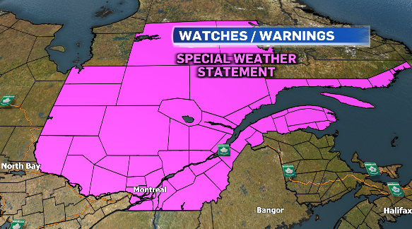 Weather watches and warnings for Quebec on Feb. 26, 2024.
Daytime highs on Tuesday and Wednesday are expected to be record-breaking in Montreal, climbing into the double digits. The high on Tuesday is expected to hit 12 degrees Celsius, which would break the previous record of 10.9 C set in 2000.
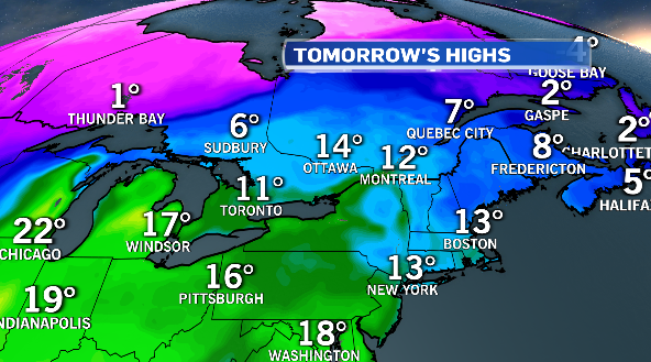 High temperatures that are expected in Quebec on Feb. 27, 2024.
The high on Wednesday is forecast to hit 14 C, which would break the previous record of 8.3 C in 2017.
The normal high for the end of February is -2 C.
A system moving into the province will bring periods of rain Tuesday night into Wednesday along with the warmer air. Montreal could see 15 to 20 millimetres of rain, which would melt any existing snow and could cause ponding on the roadways.
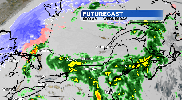 The futurecast for Quebec on Feb. 26, 2024.
A sharp cold front will swing through the region Wednesday night causing temperatures to plummet. The low Wednesday night will drop to -11 C, back to near seasonal values, but the rapid freeze will cause icy conditions and could make travel difficult.
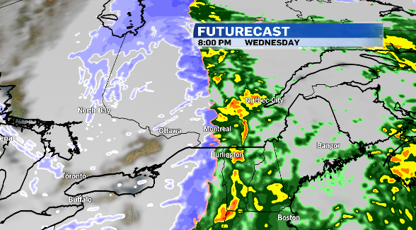 Futurecast for Wednesday, Feb. 28, 2024.
Thursday will be a colder day, with daytime highs below average at -7 C. But temperatures will climb back up above the freezing mark for Friday, and daytime highs could be back into the double digits for the first weekend of March.
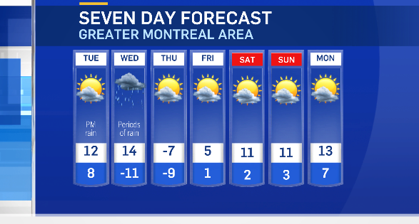 Seven-day forecast starting Feb. 26, 2024.
Shopping Trends
The Shopping Trends team is independent of the journalists at CTV News. We may earn a commission when you use our links to shop. Read about us.


CTVNews.ca Top Stories

Trump threatens to try to take back the Panama Canal. Panama's president balks at the suggestion
Donald Trump suggested Sunday that his new administration could try to regain control of the Panama Canal that the United States “foolishly” ceded to its Central American ally, contending that shippers are charged “ridiculous” fees to pass through the vital transportation channel linking the Atlantic and Pacific Oceans.
Wrongfully convicted N.B. man has mixed feelings since exoneration
Robert Mailman, 76, was exonerated on Jan. 4 of a 1983 murder for which he and his friend Walter Gillespie served lengthy prison terms.
opinion
opinion Christmas movies for people who don't like Christmas movies
The holidays can bring up a whole gamut of emotions, not just love and goodwill. So CTV film critic Richard Crouse offers up a list of Christmas movies for people who might not enjoy traditional Christmas movies.
Can the Governor General do what Pierre Poilievre is asking? This expert says no
A historically difficult week for Prime Minister Justin Trudeau and his Liberal government ended with a renewed push from Conservative Leader Pierre Poilievre to topple this government – this time in the form a letter to the Governor General.
New York City police investigate death of woman found on fire in subway car
New York City Police on Sunday were seeking a man they believe is connected to the early morning death of a woman who was sleeping on a stationary subway train before she was intentionally lit on fire.
More than 7,000 Jeep SUVs recalled in Canada over camera display concern
A software issue potentially affecting the rearview camera display in select Jeep Wagoneer and Grand Cherokee models has prompted a recall of more than 7,000 vehicles.
'I'm still thinking pinch me': lost puppy reunited with family after five years
After almost five years of searching and never giving up hope, the Tuffin family received the best Christmas gift they could have hoped for: being reunited with their long-lost puppy.
10 hospitalized after suspected carbon monoxide poisoning in Ottawa's east end
The Ottawa Police Service says ten people were taken to hospital, with one of them in life-threatening condition, after being exposed to suspected carbon monoxide in the neighbourhood of Vanier on Sunday morning.
Pickup truck driver killed by police after driving through Texas mall and injuring 5
A pickup truck driver fleeing police careened through the doors of a JCPenney store in Texas and continued through a busy mall, injuring five people before he was fatally shot by officers, authorities said.
Toronto
-

Police searching for suspect wanted for "unnecessary suffering and death" of a dog in Brampton
Police in Peel Region are asking for the public’s help to identify a man who allegedly shot and killed a dog in Brampton earlier this year.
-
Four people taken to hospital, 1 critical after house fire in Etobicoke: paramedics
Four people are in hospital and one person has critical injuries after a house fire broke out in north Etobicoke Sunday afternoon.
-
Westbound QEW, southbound Highway 403 in Oakville closed for police investigation
The westbound Queen Elizabeth Way at Winston Churchill Boulevard along with the southbound lanes of Highway 403 at Upper Middle Road in Oakville are closed due to a police investigation.
Ottawa
-

10 hospitalized after suspected carbon monoxide poisoning in Ottawa's east end
The Ottawa Police Service says ten people were taken to hospital, with one of them in life-threatening condition, after being exposed to suspected carbon monoxide in the neighbourhood of Vanier on Sunday morning.
-
WINTER TRAVEL ADVISORY
WINTER TRAVEL ADVISORY 10-20 cm of snow expected in Ottawa starting Monday
Environment Canada has issued a winter weather travel advisory for Ottawa with 10-20 centimetres of snow in the forecast on Monday.
-
What's open and closed in Ottawa over the holidays
CTVNewsOttawa.ca takes a look at what's open and closed over the Christmas and New Year's holidays this year.
Atlantic
-

Cape Breton police arrest second person in missing man investigation
A second person has been arrested in the disappearance of Justin MacDonald in Cape Breton.
-
Maritimers enjoy perfect conditions for the opening of Ski Martock near Windsor, N.S.
Ski Martock near Windsor, N.S. opened their slopes Friday, welcoming the 2024/2025 season with a layer of fresh white snow.
-
Canadian organization teaches people to combat loneliness through connection during holiday season.
For some people the holidays are lonely time of year, but a Canadian organization is fostering a “human connection movement” in an effort to bring people together.
N.L.
-

Newfoundland woman washed sick patients' hair every Saturday for more than 20 years
A retired nurse and teacher in Newfoundland was honoured this week for her volunteer work, which included more than two decades washing the hair of bedridden hospital patients.
-
Newfoundland man facing more charges related to youth sex crimes
A 64-year-old Newfoundland man charged with dozens of sex crimes involving young people is facing several new charges.
-
After fanfare of Churchill Falls deal, Newfoundland urged to learn its dam lessons
Energy observers in Newfoundland and Labrador are urging the provincial government to take a sober second look at a massive tentative deal announced last week with Quebec that promises to deliver hundreds of billions of dollars in revenue to the Atlantic province.
Northern Ontario
-

OPP investigating fatal collision Saturday in northwest Ontario
Ontario Provincial Police are investigating a fatal collision that occurred on Saturday evening in northwestern Ontario.
-
Can the Governor General do what Pierre Poilievre is asking? This expert says no
A historically difficult week for Prime Minister Justin Trudeau and his Liberal government ended with a renewed push from Conservative Leader Pierre Poilievre to topple this government – this time in the form a letter to the Governor General.
-
Northern Ont. man illegally killed three moose, one deer
A man from the northwestern Ontario community of Dinorwic has been found guilty of multiple hunting offences and fined $6,500, banned from hunting for five years and placed on probation for 18 months.
London
-

'Ford Field Experience in London': Detroit Lions host tailgate and watch party at Canada Life Place
It was a sea of Silver and Honolulu Blue on Dundas Place in London, Ont. as over 3,000 fans gathered for a Lions game on Sunday.
-
Standoff in Seaforth at the centre of SIU investigation
Following a standoff in Seaforth on Friday, the province’s police watch dog is investigating an officer’s conduct.
-
Driver charged following collision with hydro box that plunged Listowel into darkness Saturday
OPP and hydro crews were on scene on Hutton Street for much of the day working to clear the collision, and get power restored to the town.
Kitchener
-

WR Grassroots Response expands support for displaced Ukrainians with new guest house in Centre Wellington
Displaced Ukrainians finding refuge in Ontario have a new haven thanks to Grassroots Response to the Ukrainian Crisis, a Waterloo Region-based not-for-profit.
-
Can the Governor General do what Pierre Poilievre is asking? This expert says no
A historically difficult week for Prime Minister Justin Trudeau and his Liberal government ended with a renewed push from Conservative Leader Pierre Poilievre to topple this government – this time in the form a letter to the Governor General.
-
Driver in Kitchener charged after going 180km/h in 70km/h zone
A G2 driver has been charged after going 110km over the speed limit in Kitchener Sunday morning.
Windsor
-

'Giving back': Kingsville store hands out free fresh groceries ahead of the holidays
Cars lined up outside of Cindy’s Home and Garden store in Kingsville on Sunday morning for the first Green Pick-up Holiday Food Drive-Thru.
-
Looking for a last minute stocking stuffer? This local fundraiser has the thing for you.
If you’re looking for a stocking stuffer idea, consider the Kiwanis Camp Lottery Calendar! It offers $14,000 worth of prizes, including a cash prize every month and a gift up for grabs every week throughout next year.
-
Annual Christmas dinner provides 2,000 meals to Windsor-Essex families
About 30 volunteer drivers toured the region on Saturday, delivering the prepared meals, which included turkey, gravy, stuffing, dinner rolls and vegetables.
Barrie
-

Residents startled by blue flashes in the sky during power outage in Barrie
A power outage on Saturday night left over a thousand Barrie homes in the dark.
-
Police allege man failed to steal car after finding out it was standard
Barrie Police are looking for a male suspect involved in an alleged car theft attempt that ended up being unsuccessful.
-
Sauna fire creates cloud of smoke over part of Barrie's south end
Dark clouds of smoke loomed over Barrie residents from a nearby parking lot in the south end.
Vancouver
-

Second body recovered from site of B.C. landslide
The second resident of a home that was destroyed by a landslide in Lions Bay, B.C., last weekend was found dead Saturday, officials confirmed.
-
Boxes of Love brightens the season for families in need with holiday hampers
Hundreds of holiday hampers went out to low-income families across Metro Vancouver over the weekend as part of the annual Boxes of Love campaign.
-
Facing hometown Canucks 'a bit surreal' for Sharks rookie Celebrini
Macklin Celebrini grew up dreaming of playing NHL hockey at Rogers Arena. On Monday, that dream becomes a reality.
Vancouver Island
-

More strong winds hit parts of B.C.'s coast as record-high temperatures recorded
What has been a windy weekend for parts of B.C.’s coast continued Sunday as Environment Canada issued a fresh set of wind warnings.
-
Drug superlabs leave a toxic mess. Some say B.C.'s cleanup rules are a mess, too
As clandestine drug labs become larger and more complex, so does the toxic mess they leave behind and the tools required to clean them up, creating expensive and dangerous situations for both people and the environment.
-
Second body recovered from site of B.C. landslide
The second resident of a home that was destroyed by a landslide in Lions Bay, B.C., last weekend was found dead Saturday, officials confirmed.
Winnipeg
-

Minnesota-Manitoba border airport permanently shutting down after 70 years
An airport with a runway that spans across the Canada-U.S. border will close for good by the end of this week.
-
Manitoba man hopes to sell parts of unique, homemade musical instrument collection
Eighty-eight-year-old Lorne Collie has been making musical instruments for more than three decades, creations that dazzle for their unique materials as much as their sound.
-
Man attacks family with bear spray after vehicle collision: WPS
A Winnipeg man is facing several weapon-related charges after police said he attacked a family with bear spray.
Calgary
-

Police looking for driver involved in pedestrian collision in downtown Calgary.
One person is in hospital after being struck by an SUV in downtown Calgary early Saturday morning,
-
It was Grandma, in the cafe with a Scrabble tile: Game cafes are big holiday business
It’s the holidays, which means for many across the Prairies, there’s no better time to get locked in a dungeon with a dragon.
-
Calgary Firefighters Toy Association throws a Christmas party for thousands of kids at Telus Centre
The Calgary Firefighters Toy Association threw a Christmas party Sunday afternoon for about 4,000 kids at the Telus Convention Centre.
Edmonton
-

'There’s no support': Domestic abuse survivor shares difficulties leaving her relationship
An Edmonton woman who tried to flee an abusive relationship ended up back where she started in part due to a lack of shelter space.
-
Hot NHL matchup between Oilers, Senators their last action before holiday break
Two hot teams will look to create even more sparks Sunday night at Rogers Place before both sides take a holiday break.
-
AMA fundraiser for Alberta food banks nets more than $322,000
A provincial fundraiser this year has gathered its highest annual amount ever.
Regina
-

'For the community, by the community': Regina's Sikh community helping fight food insecurity
Regina's Sikh community has been helping feed those less fortunate in Regina for over seven years.
-
Gathering held in Regina to recognize Winter Solstice
Regina's mâmawêyatitân centre held a day of gathering for the Winter Solstice on Saturday.
-
Canada's first sustainable Tim Hortons location to open in Regina this weekend
Canada’s first sustainable Tim Hortons opens in Regina this weekend. The restaurant, located in the city’s east end, features design and operating features that minimize environmental impact.
Saskatoon
-
Sask. woman dead following crash on Highway 5
A 69-year-old woman from the Humboldt area is dead after her SUV collided with a truck on Highway 5, according to police.
-
Sask. police investigating mischief incident after bomb report in school
Prince Albert police are investigating a mischief incident after a bomb report in a school Friday afternoon.
-
Prince Albert woman collects donations to make Christmas hampers for community
A Prince Albert woman is spreading holiday cheer by organizing Christmas hampers for those in need.