Wicked winds and more snow headed to Montreal for first weekend of spring
The beginning of spring has felt like anything but! The first full day of spring on Wednesday was marked with accumulating snow, hail and gusty winds. And there is more winter weather on the way.
The spring air early Thursday morning was like a slap in the face. The temperature in Montreal dropped to -9 degrees Celsius and wind gusts over 50 km/h made it feel like -19.
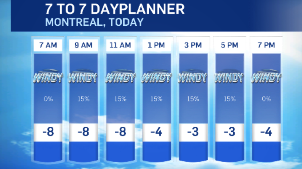
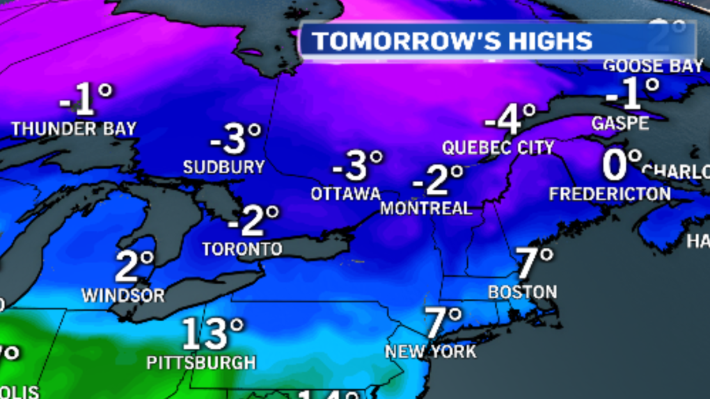
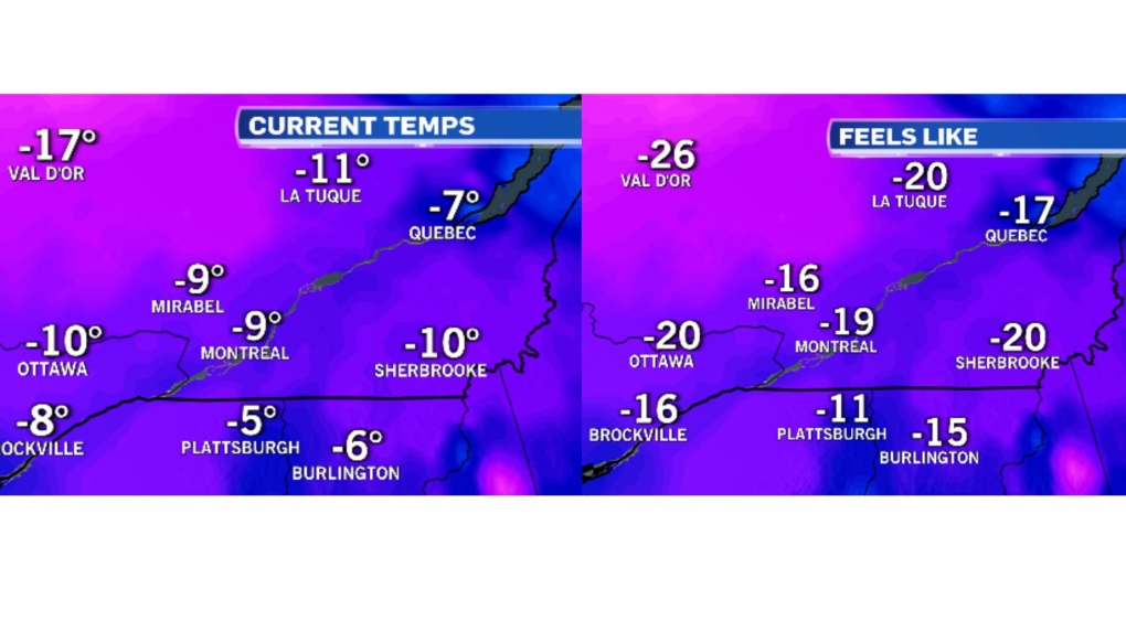 Daytime highs on Thursday are expected to be the coldest of the month so far. Montreal will see a high of only -2C, and wind gusts up to 60 km/h will make it feel like -11.
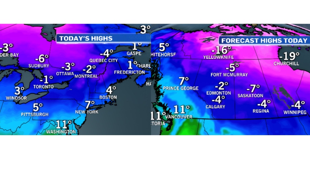
 The normal high for March 21 is 3C.
Southern Quebec is not alone when it comes to cold temperatures. The arctic air is invading much of Central Canada, and Western Canada will also see daytime highs below the freezing mark on Thursday.
 Temperatures on Thursday night across Southwestern Quebec will drop into the minus double digits and blustery winds could give windchills around -20 overnight.
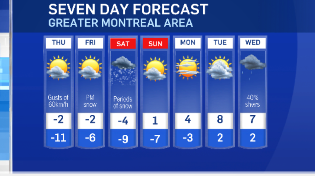
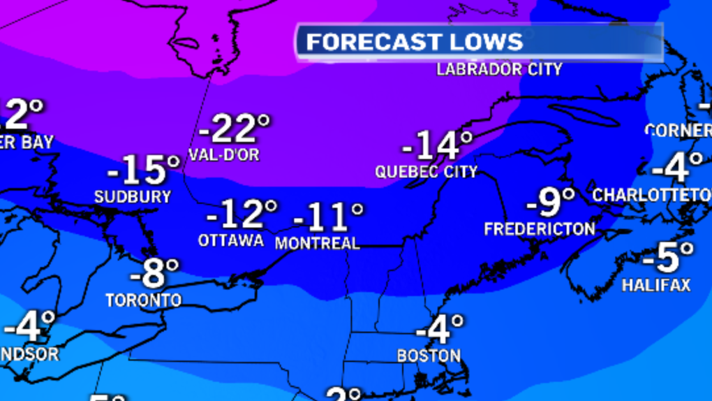 Cold air is expected to linger into Friday as well. Forecast highs are expected to stay below average and below the freezing mark.
 Meanwhile, eastern regions of the province are bracing for heavy snow.
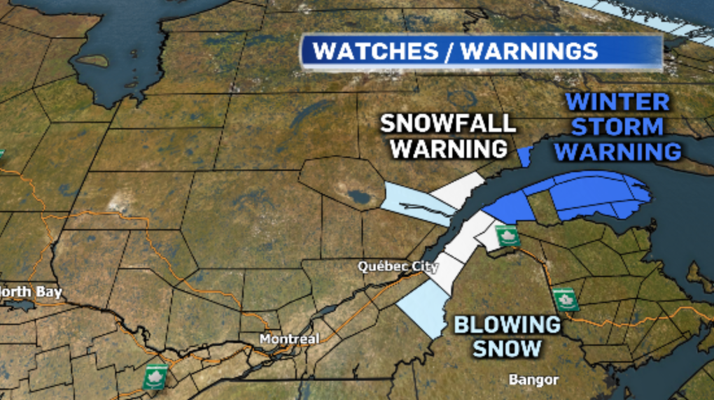 Snowfall warnings have been issued, east of Quebec City, with 15 to 25 centimetres of snow expected on Thursday. The Gaspe peninsula is under a winter storm warning with snowfall amounts of 20 to 30 cm. Gusty winds will reduce visibility and make travel difficult.
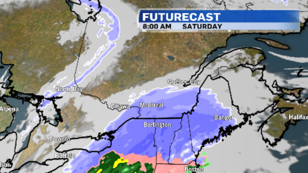
Montreal is also expecting to see more accumulating snow Friday night into Saturday as a system slides by to our south. Early indications show 5 to 10 cm is possible in the city.
 Temperatures will climb back above the freezing mark on Sunday and more spring-like conditions are anticipated through the middle of next week.
Shopping Trends
The Shopping Trends team is independent of the journalists at CTV News. We may earn a commission when you use our links to shop. Read about us.


CTVNews.ca Top Stories

Justin Trudeau to step down as PM following Liberal leadership race
Prime Minister Justin Trudeau is stepping down as Liberal leader, and is proroguing Parliament as the Liberal Party of Canada embarks on the journey to replace him.
Trudeau resignation: recap key moments, analysis, reaction as it happened
Prime Minister Justin Trudeau has stepped down as Liberal leader. Here's a recap of key moments, analysis, and reaction as it happened.
Justin Trudeau steps down as Liberal leader. Who are the top contenders to replace him?
With Prime Minister Justin Trudeau's resignation as Liberal party leader, several well-known political faces may be waiting in the wings for their opportunity to take his place.
'Together, what a great nation it would be': Donald Trump, Elon Musk react to Justin Trudeau's resignation
Amid news of Prime Minister Justin Trudeau's resignation as leader of the Liberal party on Monday morning, reactions from prominent figures began piling in.
Trudeau says Parliament is 'prorogued' until March. What does that mean?
In his resignation speech on Monday, Prime Minister Justin Trudeau announced that Parliament would be prorogued until March, which will give the Liberal party time to find a new leader ahead of an expected confidence vote and early election.
Justin Trudeau is resigning, what will be his legacy? A look back at key political eras
In a seismic political move, Justin Trudeau has announced his intention to step down as leader of the Liberal Party of Canada and prime minister, once his successor is named. This decision comes after more than nine years in the country's top job and nearly 12 years at the helm of his party.
Justin Trudeau resignation: Here's what he said in Ottawa today
Prime Minister Justin Trudeau delivered a speech about his political future Monday morning outside Rideau Cottage in Ottawa. Here's the message he delivered to Canadians.
Alberta government signs new oil and gas agreement with Enbridge
The Alberta government has signed an agreement with Enbridge that Premier Danielle Smith says will increase exports of the province's heavy oil to the United States.
Trudeau leaves mixed global legacy as he exits during turbulent time, analysts say
Prime Minister Justin Trudeau will leave the world stage with a legacy of promoting feminist causes and focusing on Asia, along with criticism that Canada's actions fell short of the government's rhetoric.
Toronto
-

Doug Ford snaps back at Donald Trump's Canada taunts with offer to 'buy Alaska'
Ontario Premier Doug Ford has snapped back at Donald Trump’s frequent taunts about treating Canada as a U.S. state with a counterproposal: buying Alaska.
-
Toronto police officer injured in pursuit of robbery suspects in North York
A Toronto police officer sustained a minor injury to his lower leg during the pursuit of several robbery suspects in North York late Monday afternoon.
-
1 arrested after vacant church in Oakville allegedly intentionally set ablaze: police
A male is in police custody after allegedly intentionally setting a vacant church in Oakville on fire late Monday morning.
Ottawa
-

Ottawa mayor says prorogation of parliament gives city time to work with MPs on transit funding request
Ottawa Mayor Mark Sutcliffe says he remains optimistic that the City of Ottawa will eventually get the transit funding it has requested from the federal government, despite Monday's announcement by Prime Minister Justin Trudeau that Parliament has been prorogued and that he intends to step aside as Liberal leader and prime minister.
-
Ottawa's new north-south O-Train opens to the public
A large crowd gathered at Bayview Station just before 6 a.m. for a chance to be the first person to ride on the new north-south Line 2 Monday morning. The new north-south Line 2 and Line 4 runs from Bayview Station to Riverside South, with a link to the Ottawa International Airport.
-
Justin Trudeau to step down as PM following Liberal leadership race
Prime Minister Justin Trudeau is stepping down as Liberal leader, and is proroguing Parliament as the Liberal Party of Canada embarks on the journey to replace him.
Atlantic
-

Names of double homicide victims in Chipman, N.B., released by police
Police in New Brunswick have released the names of two people who were killed in Chipman, N.B., late last year.
-
Maritime premiers, residents weigh-in on Trudeau resignation
Maritime leaders and residents react after Prime Minister Justin Trudeau resigned as leader of the Liberal Party on Monday.
-
Suspicious death in Bible Hill under investigation: N.S. RCMP
The Nova Scotia RCMP is investigating a suspicious sudden death in Bible Hill, N.S.
N.L.
-

Newfoundland and Labrador energy deal with Quebec under scrutiny as debate opens
Newfoundland and Labrador politicians are digging into the details of the province's draft energy deal with Quebec as four days of debate begin today in St. John's, N.L.
-
Part of street washed away and state of emergency declared in N.L. town after storm
Damaging winds and pounding surf that washed away part of a street in a small northeastern town in Newfoundland on Sunday triggered a state of emergency in the coastal community.
-
Newfoundland residents seek answers, assurance as Quebec energy deal heads for debate
About 50 people gathered in a St. John's, N.L., gymnasium on a recent rainy night to seek answers about a massive energy deal with Hydro-Quebec trumpeted by the Newfoundland and Labrador government as a new chapter in the province's history.
Northern Ontario
-
Justin Trudeau to step down as PM following Liberal leadership race
Prime Minister Justin Trudeau is stepping down as Liberal leader, and is proroguing Parliament as the Liberal Party of Canada embarks on the journey to replace him.
-
Two Greater Sudbury drivers charged in racing incident on Hwy. 69
Ontario Provincial Police stopped to vehicles travelling more than double the speed limit on Highway 69 south of Greater Sudbury, early Friday morning.
-
Province boosts Sudbury's annual funding by $2.7M
The City of Greater Sudbury is one of more than 300 municipalities receiving an increase to their annual provincial funding this year.
London
-

Body found on Lake Erie shoreline prompts death investigation
Elgin County OPP are investigating after a deceased individual was discovered on the shoreline of Lake Erie in the township of Malahide.
-
Truck driver slapped with charges after screwing a hitch to the floor of a cube van: OPP
Lambton OPP have laid charges against a commercial motor vehicle operator who improvised a trailer hitch by screwing a hitch into the floor of a cube van.
-
Strangulation attack inside Sarnia church sparks security review
The incident happened Saturday inside the Adoration Chapel at Our Lady of Mercy Catholic Church - the chapel is available 24 hours a day for those who know the door code to enter.
Kitchener
-

Uncertainty surrounds college semester in Ontario as strike deadline looms
Students at Ontario’s 24 public colleges are beginning their winter semester under the cloud of a potential strike.
-
Justin Trudeau to step down as PM following Liberal leadership race
Prime Minister Justin Trudeau is stepping down as Liberal leader, and is proroguing Parliament as the Liberal Party of Canada embarks on the journey to replace him.
-
Social media famous corgi from Kitchener, Ont. rescues owner
A captivating canine is being hailed as a hero after one of his owners took a terrifying fall.
Windsor
-

Riders push back against proposed $1.4M Transit Windsor cut
Details of the $1.4-million cut have not been made public, as the document outlining Windsor's proposed budget lists it as an "in-camera item" – meaning it will be discussed behind closed doors by Windsor's mayor, city councillors and administration.
-
'It is a nice piece of history': remnants of possible 19th century schooner shipwreck wash up in Erieau
Former Erieau harbourmaster Jeff Vidler hopes to salvage and preserve the large section of the vessel, believing it to be from a wooden schooner that was likely built in the 1850's.
-
Three gunpoint robbery suspects sought, one arrested
Windsor police officers have arrested one suspect and they are looking for three others after an armed robbery on University Avenue.
Barrie
-

Former Snowbirds pilot charged with sexual assault testifies in Barrie court
A former Canadian Forces Snowbirds pilot accused of forcing himself on a colleague before last summer’s airshow in Barrie took the stand to clear his name in court on Monday.
-
Collision involving snowmobile at Hwy 12 crossing under investigation
Provincial police are investigating a collision involving a snowmobile in Midland.
-
Rookie driver charged with speeding over 2x posted limit: OPP
Provincial police say a G2 driver faces serious charges after being clocked speeding more than double the posted limit in the Town of New Tecumseth over the weekend.
Vancouver
-

B.C. politicians front and centre: Singh, Clark, others on federal stage
As the fallout from Justin Trudeau’s much-anticipated resignation announcement reverberates across Canada, at least two British Columbians will feature prominently in national politics in the coming weeks and months.
-
Hidden in plain sight: Human trafficking and the B.C. connection
You may not see it or even know it’s happening in your community. But it is an evil shrouded in the dark shadows of society, and even experts do not know its full scope.
-
January blues? B.C. Doctor shares winter mental health tips
A Lower Mainland family physician who specializes in mental health says January can be a challenging time, as people transition out of the busy holiday season and re-establish their routines.
Vancouver Island
-
B.C. politicians front and centre: Singh, Clark, others on federal stage
As the fallout from Justin Trudeau’s much-anticipated resignation announcement reverberates across Canada, at least two British Columbians will feature prominently in national politics in the coming weeks and months.
-
CBSA says it acted in 'good faith' detaining solar panels in forced labour probe
The Canada Border Services Agency says it acted lawfully and in "good faith" when it detained nearly 50 containers of solar panels belonging to a Victoria, B.C., company over concerns they were made using forced labour.
-
Victoria police cleared of wrongdoing in crash that killed 24-year-old taxi driver
British Columbia's police oversight agency has cleared Victoria police officers of wrongdoing after an attempted traffic stop on a city street led to the death of an innocent man last year.
Winnipeg
-

'Different life to the party': Manitoba weighs in on Trudeau’s resignation
Manitobans are reacting to Justin Trudeau’s resignation as Liberal leader and his decision to prorogue to Parliament until March to allow for a leadership race.
-
Injunction extended against protesters in Lemay Forest
A court-ordered injunction against a group protesting the clearing of a Winnipeg forest will remain in place.
-
Man charged with voyeurism at Winnipeg fitness facility
A 26-year-old man has been charged with voyeurism after he allegedly snapped photos of a child undressing in a change room at a Winnipeg fitness facility.
Calgary
-
Justin Trudeau to step down as PM following Liberal leadership race
Prime Minister Justin Trudeau is stepping down as Liberal leader, and is proroguing Parliament as the Liberal Party of Canada embarks on the journey to replace him.
-
Calgary's lone Liberal MP thanks Trudeau, but says it was time for him to go
Justin Trudeau's announcement on Monday that he intends to resign as prime minister and Liberal leader was needed "to move our country forward," says Calgary's only Liberal MP.
-
Alberta government signs new oil and gas agreement with Enbridge
The Alberta government has signed an agreement with Enbridge that Premier Danielle Smith says will increase exports of the province's heavy oil to the United States.
Edmonton
-

Alberta faces potential short-term gain, long-term pain after Trudeau quits as prime minister
Justin Trudeau's resignation as Canada's prime minister and leader of the Liberal party should benefit the province in the short term, but long-term, the importance of free trade should be central to any Albertan or Canadian effort to sway U.S. opinion with the spectre of potentially crushing tariffs looming, pundits say.
-
'We're in an epidemic': Deaths of two women in alleged domestic abuse cases raising red flags
Advocates for domestic abuse survivors say the deaths of an Edmonton woman and a Calgary mother and her father over the holidays shows domestic abuse is an “epidemic.”
-
Alberta Energy Regulator lacks evidence for tailings spill cleanup claims: ecologist's study
A new analysis of a decade's worth of data kept by Alberta's oil and gas regulator suggests the agency has made unsubstantiated claims about the success of oilsands tailings spills cleanup.
Regina
-

Trudeau's resignation could lead to changes for Sask/Ottawa relationship
Premier Scott Moe and the Saskatchewan Party will be losing its most prominent "opponent" in the coming months – with Prime Minister Justin Trudeau announcing he intends to step down pending a leadership race.
-
Sask. RCMP make arrest in suspicious death on Piapot First Nation
Saskatchewan RCMP have arrested and charged Robin Kaiswatum, 40, with second degree murder in connection to a death on Piapot First Nation.
-
Saskatchewan politicians react to Trudeau's resignation announcement
Following Prime Minister Justin Trudeau's resignation announcement on Monday, reaction from politicians around the world quickly began to circulate, including in Saskatchewan.
Saskatoon
-

Judge condemns murder trial delay, asks lawyers to 'turn around' and look at the public 'we serve'
A Saskatoon murder trial opened on Monday with the judge sharply criticizing the time it’s taken to get to trial.
-
These 90-year-old identical twins were born in a Saskatchewan barn, but grew to love the city
Rose Worona and Anne Skwarchuk were born in 1935 on a farm near Hafford. Now, they’re celebrating their 90th birthday together.
-
Province calling for prospective builders on new Sask. Polytech campus in Saskatoon
The province is putting out the call to prospective builders for a major project on the new Saskatchewan Polytechnic campus planned in Saskatoon.