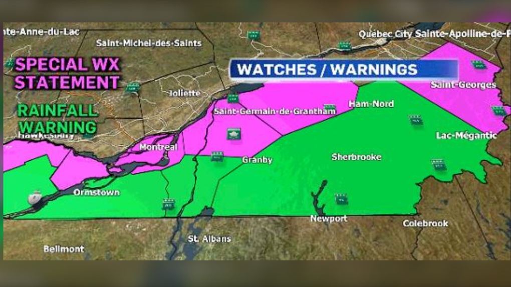
Significant rainfall coming to Montreal on Wednesday afternoon
Heavy rains are coming to Southern Quebec on Wednesday afternoon, as the remnants of tropical storm Beryl could bring up to 60 millimetres of rain.
Environment and Climate Change Canada has issued a rainfall warning for the following areas:
- Metro Montreal - Laval
- Vaudreuil area
- Valleyfield - Beauharnois area
- Mont-Orford - Lake Memphrémagog area
- Sherbrooke area
Rainfall amounts between 40 and 70 millimetres are expected, along with moderate winds. Rainfall amounts could exceed 100 millimetres, and could include thunderstorms.
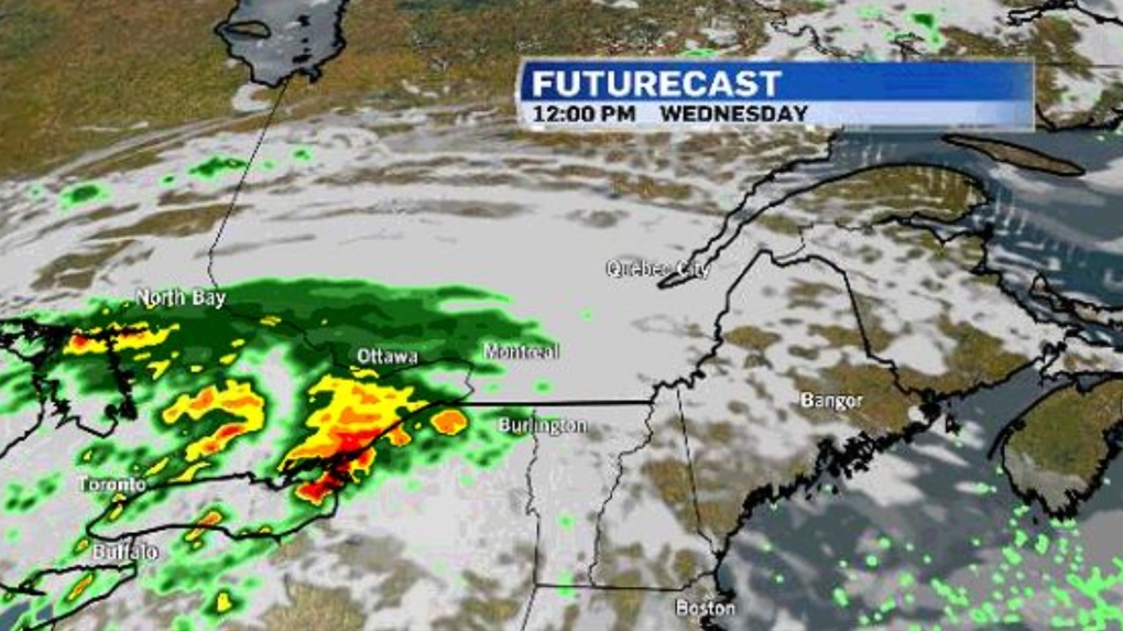
David Phillips, senior climatologist with Environment and Climate Change Canada, says this system still has a lot of uncertainty.
"We have seen the system actually move a little further south. So it actually goes south of Montreal, but it is not going to miss Montreal," Phillips says.
"Montreal is clearly going to see the rain from this. It may just not be the amounts that they will see further south and further east, say the Eastern Townships."
"If the system slows down when it enters Canada, that slowing down can be a problem because then it has more time to spread its misery. If it slows down, it's going to pour down more," he noted.
"If the rain falls intensely, it could cause some pooling and ponding and intersections could be flooded and maybe basements."
Localized flooding in low-lying areas is possible.
According to Phillips, Montreal has already seen 30 per cent more rainfall in the last four months.
The rain will bring cooler temperatures but is expected to warm up again by the weekend.
"We will be back into temperature that would be 29 to 31 degrees which is four or five degrees warmer than normal."
Shopping Trends
The Shopping Trends team is independent of the journalists at CTV News. We may earn a commission when you use our links to shop. Read about us.


CTVNews.ca Top Stories

W5 Investigates
W5 Investigates A 'ticking time bomb': Inside Syria's toughest prison holding accused high-ranking ISIS members
In the last of a three-part investigation, W5's Avery Haines was given rare access to a Syrian prison, where thousands of accused high-ranking ISIS members are being held.
Trudeau Liberals' two-month GST holiday bill passes the House, off to the Senate
The federal government's five-page piece of legislation to enact Prime Minister Justin Trudeau's promised two-month tax break on a range of consumer goods over the holidays passed in the House of Commons late Thursday.
Irregular sleep patterns may raise risk of heart attack and stroke, study suggests
Sleeping and waking up at different times is associated with an increased risk of heart attack and stroke, even for people who get the recommended amount of sleep, according to new research.
California man who went missing for 25 years found after sister sees his picture in the news
It’s a Thanksgiving miracle for one California family after a man who went missing in 1999 was found 25 years later when his sister saw a photo of him in an online article, authorities said.
As Australia bans social media for children, Quebec is paying close attention
As Australia moves to ban social media for children under 16, Quebec is debating whether to follow suit.
Notre Dame Cathedral: Sneak peak ahead of the reopening
After more than five years of frenetic reconstruction work, Notre Dame Cathedral showed its new self to the world Friday, with rebuilt soaring ceilings and creamy good-as-new stonework erasing somber memories of its devastating fire in 2019.
Canada Post temporarily laying off striking workers, union says
The union representing Canada Post workers says the Crown corporation has been laying off striking employees as the labour action by more than 55,000 workers approaches the two-week mark.
Can't resist Black Friday weekend deals? How to shop while staying within your budget
A budgeting expert says there are a number of ways shoppers can avoid getting enveloped by the sales frenzy and resist spending beyond their means.
Montreal shopping mall playing 'Baby Shark' song to prevent unhoused from loitering
A shopping mall and office complex in downtown Montreal is being criticized for using the popular children's song 'Baby Shark' to discourage unhoused people from loitering in its emergency exit stairwells.
Toronto
-

Black Friday sales stretch out for weeks: retail analyst
Black Friday is officially the busiest shopping day of the year, even surpassing Boxing Day and Super Saturday, the final Saturday before Christmas.
-
Video appears to show armed suspect attempting to carjack several drivers in Toronto's east end
Toronto police have released new details about a series of attempted carjackings and shootings that left one person seriously injured in Toronto’s east end on Wednesday night.
-
Ontario won't support making Truth and Reconciliation Day a holiday for now: minister
Premier Doug Ford's government will not support a New Democrat's bill to make the National Day for Truth and Reconciliation a statutory holiday in the province, the Indigenous affairs minister said Thursday.
Ottawa
-

'Dude, Where's My Bus?' Ottawa man fed up with OC Transpo makes documentary exploring transit troubles
Gio Petti put together a documentary on OC Transpo, asking how we got here. How did a city that was once lauded as an example of how to do transit right, and that boasted some of the highest per capita transit ridership numbers in the country, become a system that now elicits so much frustration from users?
-
NEW THIS MORNING
NEW THIS MORNING Ottawa to begin full enforcement of 3-item garbage limit on Monday: Here’s what you need to know
The City of Ottawa will begin the final phase of the graduated approach to enforcing the city’s new three-item garbage limit on Monday, leaving behind any extra items not in a yellow bag.
-
Here's how it feels this Friday in Ottawa
Clouds and flurries are in the forecast for Ottawa this Friday.
Atlantic
-

Storm Watch: School closures, cancellations
School cancellations and delays in the Marititmes for Friday, Nov. 29
-
'Everybody's on guard': Residents shaken after bodies found inside burning SUV in Chipman, N.B.
Residents of Chipman, N.B., are expressing their shock after the bodies of two people were found inside a burning vehicle in the community this week.
-
Gas prices fall in N.S., P.E.I., increase slightly in N.B.
Gas prices change in all three Maritime provinces.
N.L.
-

'Who profits on hunger?': Inuit send pleading emails to minister about food costs
People in Nunavut and northern Labrador have been writing to Canadian government officials this year to say grocers were charging exorbitant prices despite receiving a federal subsidy.
-
As N.L. firm pivots, scientists say Canada's green hydrogen dreams are far-fetched
A Newfoundland energy company's embrace of data centres is raising doubts about eastern Canadian hopes of harnessing the region's howling winds to supply Germany with power from green hydrogen.
-
Canadian leads group pushing Vatican for zero-tolerance policy on abuse by clergy
An international group led by a Canadian is in Rome this week to push the Catholic Church to adopt a zero-tolerance policy on abuse by clergy.
Northern Ontario
-

Northern Ontario site selected for nuclear waste underground repository
A region in northern Ontario has been chosen as the site to hold Canada's nuclear waste in a deep geological repository.
-
Ongoing bed bug issue at a Timmins apartment building is 'like living in hell'
A battle with bed bugs continues at 217 Pine St. North in Timmins, according to a tenant who has lived there for a year and a half.
-
Sudbury family donates $1M to Health Sciences North Foundation
Di Brina Family Holdings announced Thursday it is donating $1 million to the Health Sciences North Foundation.
London
-

Knights' Boulton hit with eight-game suspension
The left winger has been suspended eight games, retroactive to Nov. 23 against Saginaw, when he was handed a major penalty for slashing, along with a game misconduct.
-
Dundas Place to be car-free more consistently with weekend schedule
City hall is once again considering changes to when Dundas Place transforms into a pedestrian-only street, but the city councillor representing Downtown London doesn’t think the time is right for scheduling weekly closures to traffic.
-
Knights blank Petes in Peterborough
Six different goal scorers found the back of the net for London, while goalie Alexei Medvedev made 31-saves for the shutout.
Kitchener
-

One dead, another hurt in Cambridge shooting
Waterloo Regional Police are investigating a fatal shooting in Cambridge.
-
Mother from Guelph, Ont. seeks answers following son's death in prison
Brody Robinson was found without vital signs in his cell at Millhaven Institution the evening of Oct. 29. He was 23-years-old.
-
Flurries, possibly even snow squalls, in southern Ontario’s forecast
Winter finally arrives this week in southern Ontario. Environment Canada is forecasting flurries and snow squalls almost every day.
Windsor
-

Injury reported at NextStar Engery plant work site
The Ministry of Labour is investigating after an injury at the construction site of the NextStar Energy battery plant.
-
One man sought, one man arrested in kidnapping and extortion investigation
Windsor police officers have charged one man with 29 offences and they are seeking a second suspect in a kidnapping and extortion investigation.
-
Wrong-way driver arrested on E.C. Row Expressway
Windsor police say a 47-year-old man is facing impaired driving charges after going the wrong way on the E.C. Row Expressway.
Barrie
-

50 cms of snow across central Ontario expected this weekend
Environment Canada has released snow squall warnings and watches for our region.
-
School bus cancellations by board
See current school bus cancellations by school board from across the region.
-
Individuals living in encampment in Barrie's south end given notice to vacate
Several police officers and city staff attended a homeless encampment in Barrie’s south end on Thursday morning to inform the individuals living there they would have to vacate the area.
Vancouver
-

Could Vancouver's public funds be used for investments in cryptocurrency?
Vancouver Mayor Ken Sim has apparently expressed interest in cryptocurrency investments.
-
'Completely preventable': Wheel flies off dump truck on B.C. highway, striking SUV head-on
A dump truck driver has been handed more than $700 in fines after one of his wheels detached and flew into the front of an oncoming SUV in B.C.’s Fraser Valley on Thursday.
-
Suspect arrested in vandalism at Maple Ridge tea shop, RCMP say
Two months after a Maple Ridge tea shop was targeted in an alarming act of vandalism, authorities have identified a suspect.
Vancouver Island
-

Avian flu case discovered in Greater Victoria, officials confirm
The Canadian Food Inspection Agency (CFIA) has confirmed a case of avian flu has been detected in Greater Victoria, on the Saanich Peninsula.
-
Penelakut Island food stores spoil after power outage during B.C. windstorm
Hundreds of people on B.C.'s Penelakut Island are staring down a winter without their essential food stores.
-
Stolen Dodge pickup used in theft of 2nd Dodge truck, B.C. RCMP say
Authorities are asking for the public’s help tracking down at least two suspects who used a stolen Dodge pickup to steal a second Dodge truck in Greater Victoria this month.
Winnipeg
-

Hanover School Division laying off 93 EAs due to confusion over funding
The Hanover School Division is laying off 93 educational assistants, citing an "unexpected loss of federal funding for Jordan's Principle programming."
-
A tale of two downtowns: Restaurants opening and closing show complexity of downtown revival
Proposed developments and new businesses opening are fueling optimism for some on a revival of downtown Winnipeg, but some business owners say the present remains problematic.
-
Art auctioned from WAG-Qaumajuq to make way for new pieces representing Winnipeg
Visitors to the Winnipeg Art Gallery-Qaumajuq may soon see some brand new art hanging on its walls.
Calgary
-

Pedestrian killed after being hit by two vehicles while crossing Elbow Drive
Calgary police say a pedestrian was hit and killed while crossing Elbow Drive S.W. on Wednesday evening.
-
Alberta will patrol shared border with Montana as tariff threat looms: premier
Alberta Premier Danielle Smith says the province is ready to take border security into its own hands.
-
Consumers' choices thin, as are butchers' margins, with meat prices up
Many shoppers are avoiding expensive cuts or buying smaller quantities of meat.
Edmonton
-

Alberta will patrol shared border with Montana as tariff threat looms: premier
Alberta Premier Danielle Smith says the province is ready to take border security into its own hands.
-
'We want a negotiated contract': Local Canada Post workers remain steadfast as strike continues
Postal workers in Edmonton are holding their picket lines as the Canada Post strike nears its third week.
-
Canada Post temporarily laying off striking workers, union says
The union representing Canada Post workers says the Crown corporation has been laying off striking employees as the labour action by more than 55,000 workers approaches the two-week mark.
Regina
-

Crown gives final remarks in Ruben Manz case as argument to jury concludes
The prosecution has presented their closing remarks against Ruben Manz to a 13-person jury, bringing an end to arguments before their sequestering.
-
Youngest roping duo looking for repeat performance at Agribition Rodeo
Kavis Drake, 18, and Denim Ross, 20, won the average in last year’s Maple Leaf Finals Rodeo team roping event at Agribition. The two were the youngest competitors in 2023 and are once again in their event this year.
-
Sentencing submissions presented in case of woman who defrauded Regina Mobile Crisis Services
The Crown and defence presented sentencing submissions at Saskatchewan Provincial Court on Thursday, in the case of a woman who pleaded guilty to defrauding Regina Mobile Crisis Services.
Saskatoon
-

Extreme cold warning issued for Saskatoon
Environment Canada has issued an extreme cold warning for parts of central Saskatchewan, including Saskatoon, on Thursday.
-
Sask. forecasting $743.5M deficit in mid-year financial report, up $470.5M from budget
The provincial government says increases to crop insurance claims later in the growing season are a main reason for Thursday’s mid-year deficit forecast of $743.5 million, which is up more than $470 million from the budget.
-
'Got to deal with it': Saskatoon residents dealing with bumpy, snowy roads
Most of the main roads in Saskatoon are cleared, but feeder streets and residential roads are a different story.