Don’t let the snowbanks outside fool you – it is, in fact, the first day of spring.
While we’ll have seasonal temperatures and mainly clear skies Monday morning, the winter-like weather isn’t yet over. We’ll have to suffer through a bit more snow and cold before we see those April showers and (…finally!) May flowers.
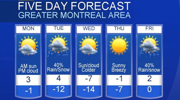
Clouds are expected to increase throughout the day Monday with an afternoon high of 3 degrees Celsius before dropping just below the freezing mark overnight.
A few flurries are expected Monday evening followed by a rain or snow shower Tuesday morning. Tuesday should see a high of 4 degrees before it dips down to -12 overnight.
Much colder weather is headed our way along with flurries on Wednesday (say it ain’t so!) as a trough of low pressure moves across the region. We’ll be looking at temperatures topping -7 and going as low as -14, with north-northeast winds of 30 to 40 kilometres per hour. Brrr.
Thursday will be partly sunny and cold with a high of -1 with a low of -6.
Then the next system moves in, bringing with it a rain or snow shower later in the day Friday. It’s won’t be as cold (a little above 0), but we may see a rain or snow shower in spots in the afternoon.
Though it might be a little damp and chilly this week, there’s some good news: Environment Canada is forecasting a warmer than normal spring, and believes Quebec will be one of the first provinces to snap out of wintry weather.
“We think the flavour, the personality, of spring over a good chunk of the country is going to be warmer than normal,” said senior climatologist Dave Phillips.

